IMAGES TAKEN NEAR TO
Lower Monk Street, ABERGAVENNY, NP7 5JR
Introduction
This page details the photographs taken nearby to Lower Monk Street, NP7 5JR by members of the Geograph project.
The Geograph project started in 2005 with the aim of publishing, organising and preserving representative images for every square kilometre of Great Britain, Ireland and the Isle of Man.

There are currently over 7.5m images from over14,400 individuals and you can help contribute to the project by visiting https://www.geograph.org.uk
Image Map
Images are licensed for reuse under creativecommons.org/licenses/by-sa/2.0
Notes
- Clicking on the map will re-center to the selected point.
- The higher the marker number, the further away the image location is from the centre of the postcode.
Image Listing (886 Images Found)
Images are licensed for reuse under creativecommons.org/licenses/by-sa/2.0
Image
Details
Distance
1
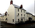
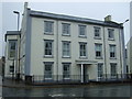
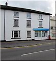
Grade II listed former residence of the Chief Constable of Monmouthshire, Abergavenny
The Lower Monk Street house is next door to the former police headquarters. https://www.geograph.org.uk/photo/5643644
Cadw records that the early 19th century house was fully refurbished in c2002. Grade II listed in 1974.
Image: © Jaggery
Taken: 31 Dec 2017
0.01 miles
2
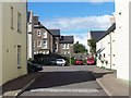
New Housing In Abergavenny
This cul-de-sac leads of Lower Monk Street. It doesn't appear to have a specific name, but is made up of Osborne House and Osborne Close.
Image: © Geoff Pick
Taken: 7 Aug 2010
0.01 miles
3
Junction at the start of the B4233 in Abergavenny
Image: © Rob Purvis
Taken: 26 Aug 2015
0.02 miles
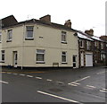
4
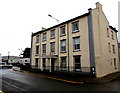
Grade II listed former police headquarters, Abergavenny
The Lower Monk Street side of the three-storey building on the corner of Monk Street, built in the late 18th century. It was extended in the early 20th century on becoming a gentlemen's club. In the mid 20th century it was the Monmouthshire County Police Headquarters until 1974 when the renamed Gwent Police Force moved to headquarters in Cwmbran. For about 20 years thereafter, it was Abergavenny Division Police Headquarters. Newly refurbished and extended at the start of the 21st century, the building is now in residential use. Grade II listed in 1952.
Image: © Jaggery
Taken: 31 Dec 2017
0.02 miles
6
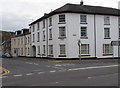
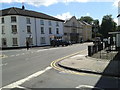
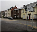
Junction of Monk Street and Lower Monk Street, Abergavenny
On the right, the sign alongside the A40 Monk Street points towards the B4233 Lower Monk Street. The sign shows 12 (miles) to Rockfield, half a mile to Pen-y-fal. St Mary's Court flats are on the corner.
This is the western end of the B4233 which extends for 23km to Monmouth via Llantilio Crossenny. The Sabre website states that the B4233 has the distinction of being the lowest numbered Class II road wholly in Wales in the 1922 Road Lists.
Image: © Jaggery
Taken: 30 Sep 2018
0.02 miles
7
Junction of Ross Road and Lower Monk Street, Abergavenny
The southern end of Ross Road viewed across the B4233 Lower Monk Street.
Image: © Jaggery
Taken: 31 Dec 2017
0.02 miles
8
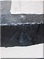
Ordnance Survey Rivet
This OS rivet can be found on a window sill of the London Hotel. It marks a point 58.680m above mean sea level.
Image: © Adrian Dust
Taken: 4 Jun 2014
0.02 miles
9
B4233 direction sign, Monk Street, Abergavenny
Alongside the A40 Monk Street 12 miles from Rockfield.
The junction behind the camera is the western end of the B4233 from Monmouth.
Image: © Jaggery
Taken: 31 Dec 2017
0.03 miles
10
MPS Surveying & Architectural Design office in Abergavenny
Viewed across the A40 Monk Street.
Image: © Jaggery
Taken: 30 Sep 2018
0.03 miles