IMAGES TAKEN NEAR TO
Saleyard, ABERGAVENNY, NP7 0HD
Introduction
This page details the photographs taken nearby to Saleyard, NP7 0HD by members of the Geograph project.
The Geograph project started in 2005 with the aim of publishing, organising and preserving representative images for every square kilometre of Great Britain, Ireland and the Isle of Man.

There are currently over 7.5m images from over14,400 individuals and you can help contribute to the project by visiting https://www.geograph.org.uk
Image Map
Images are licensed for reuse under creativecommons.org/licenses/by-sa/2.0
Notes
- Clicking on the map will re-center to the selected point.
- The higher the marker number, the further away the image location is from the centre of the postcode.
Image Listing (22 Images Found)
Images are licensed for reuse under creativecommons.org/licenses/by-sa/2.0
Image
Details
Distance
1
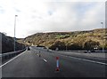
Heads of the Valley Road near Clydach
Image: © Roger Cornfoot
Taken: 9 Dec 2018
0.03 miles
2
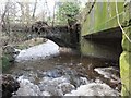
Former crossings
View up the Afon Clydach beneath old and older bridges; the modern crossing of the river by the A465 is to the right of this shot.
Image: © Alan Bowring
Taken: 19 Jan 2014
0.05 miles
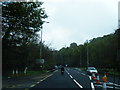
4
Road works ahead
The adjacent A465 Heads of the Valleys Road is being widened along the Clydach valley.
Image: © Jonathan Billinger
Taken: 10 Jun 2016
0.07 miles
5
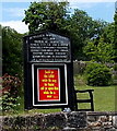
Bethlehem Baptist Chapel information board, Clydach
Located here, http://www.geograph.org.uk/photo/3508393 the board shows that the chapel was established in 1830.
Image: © Jaggery
Taken: 7 Jun 2013
0.12 miles
6
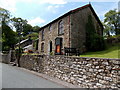
Bethlehem Chapel, Cottage and Manse, Clydach
Bethlehem Cottage and Bethlehem Manse are behind Bethlehem Chapel.
The information board http://www.geograph.org.uk/photo/3508397 shows that the chapel was established in 1830.
Image: © Jaggery
Taken: 7 Jun 2013
0.12 miles
7
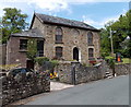
Bethlehem Baptist Chapel viewed from the south, Clydach
The information board http://www.geograph.org.uk/photo/3508397 states that the chapel was established in 1830.
Image: © Jaggery
Taken: 7 Jun 2013
0.13 miles
8
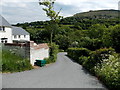
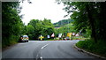
Unnamed road from Maesygwartha to the A465 Heads of the Valleys road
Viewed from near the western boundary sign http://www.geograph.org.uk/photo/3508428 for Maesygwartha.
Image: © Jaggery
Taken: 7 Jun 2013
0.15 miles
9
Western boundary of Maesygwartha
The old road from Brynmawr to Gilwern reaches Maesygwartha, a small village in Monmouthshire.
Image: © Jaggery
Taken: 7 Jun 2013
0.17 miles
10
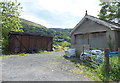
A new use for an old railway wagon body, Clydach
Throughout the UK, there must be thousands, perhaps tens of thousands, of similar former railway wagon bodies now in use for storage.
Image: © Jaggery
Taken: 7 Jun 2013
0.17 miles