IMAGES TAKEN NEAR TO
Orchard Close, ABERGAVENNY, NP7 0EN
Introduction
This page details the photographs taken nearby to Orchard Close, NP7 0EN by members of the Geograph project.
The Geograph project started in 2005 with the aim of publishing, organising and preserving representative images for every square kilometre of Great Britain, Ireland and the Isle of Man.

There are currently over 7.5m images from over14,400 individuals and you can help contribute to the project by visiting https://www.geograph.org.uk
Image Map
Images are licensed for reuse under creativecommons.org/licenses/by-sa/2.0
Notes
- Clicking on the map will re-center to the selected point.
- The higher the marker number, the further away the image location is from the centre of the postcode.
Image Listing (84 Images Found)
Images are licensed for reuse under creativecommons.org/licenses/by-sa/2.0
Image
Details
Distance
1
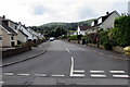
Orchard Close, Gilwern
Cul-de-sac on the south side of Church Road.
Image: © Jaggery
Taken: 20 Aug 2017
0.02 miles
2
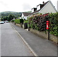
Queen Elizabeth II postbox, Orchard Close, Gilwern
Viewed from Church Road.
Image: © Jaggery
Taken: 20 Aug 2017
0.06 miles
3
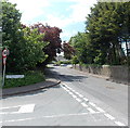
Corner of Maesygwartha Road and Church Road, Gilwern
Looking west along Church Road.
Image: © Jaggery
Taken: 7 Jun 2013
0.08 miles
4
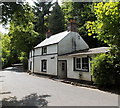
Machine House, Maesygwartha Road
Located between Maesygwartha and Gilwern. The road was formerly part of Clydach Railroad, a late 18th century tramroad which connected coal and iron ore mines, limestone quarries and ironworks at the head of the Clydach Gorge with the canal at Gilwern. Wagons descended by gravity (controlled with brakes) and were hauled back up by horses.
Image: © Jaggery
Taken: 7 Jun 2013
0.09 miles
5
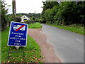
Bilingual temporary road sign, Maesygwartha Road, Gilwern
The sign faces Church Road here. http://www.geograph.org.uk/photo/5507039 The sign suggests that the Welsh for HGVs is also HGVs which is curious because the Welsh for Heavy goods vehicles is Cerbydau nwyddau trwm. Also, there is no letter V in the standard Welsh alphabet and the letter s does not usually indicate a plural in Welsh.
Image: © Jaggery
Taken: 20 Aug 2017
0.11 miles
6
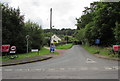
Maesygwartha Road, Gilwern
The northern end of Maesygwartha Road, viewed across Church Road. In August 2017, two temporary signs show NO CONSTRUCTION TRAFFIC and the Welsh equivalent. Other signs show that the road ahead is unsuitable for heavy goods vehicles. There is a 7.5 tonnes vehicle weight limit, except for access. The 30mph speed limit on Church Road increases to the National Speed Limit.
Image: © Jaggery
Taken: 20 Aug 2017
0.11 miles
7
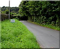
Please do not litter notice, Maesygwartha Road, Gilwern
In August 2017 the notice shows PLEASE DO NOT LITTER - Recently Cleared by Volunteers.
Image: © Jaggery
Taken: 20 Aug 2017
0.11 miles
8
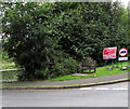
Memorial wooden bench on a Gilwern corner
On the corner of Maesygwartha Road and Church Road near the Monmouthshire and Brecon Canal.
The bench is dedicated in memory of Councillor Jenny Wilce for her services to the community of Llanelly Parish.
Image: © Jaggery
Taken: 20 Aug 2017
0.11 miles
9
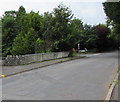
Church Road canal bridge, Gilwern
Church Road crosses bridge 104 http://www.geograph.org.uk/photo/5507025 over the Monmouthshire and Brecon Canal.
Image: © Jaggery
Taken: 20 Aug 2017
0.12 miles
10
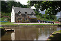
Gilwern Wharf
The house on the opposite bank incorporates a canal gift shop.
Image: © Stephen McKay
Taken: 23 Jul 2009
0.12 miles