IMAGES TAKEN NEAR TO
Main Road, ABERGAVENNY, NP7 0AR
Introduction
This page details the photographs taken nearby to Main Road, NP7 0AR by members of the Geograph project.
The Geograph project started in 2005 with the aim of publishing, organising and preserving representative images for every square kilometre of Great Britain, Ireland and the Isle of Man.

There are currently over 7.5m images from over14,400 individuals and you can help contribute to the project by visiting https://www.geograph.org.uk
Image Map
Images are licensed for reuse under creativecommons.org/licenses/by-sa/2.0
Notes
- Clicking on the map will re-center to the selected point.
- The higher the marker number, the further away the image location is from the centre of the postcode.
Image Listing (192 Images Found)
Images are licensed for reuse under creativecommons.org/licenses/by-sa/2.0
Image
Details
Distance
1
Beaufort Arms, Gilwern
Located inside a triangle bordered by Crickhowell Road, Main Road, and the short connecting road between them. Originally a coaching inn, the Beaufort Arms is now a pub with bed & breakfast accommodation, bar meals and Sunday lunches available.
Image: © Jaggery
Taken: 13 Aug 2017
0.00 miles
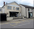
2
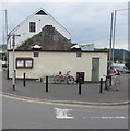
Gilwern public toilets
On the corner of Main Road and Crickhowell Road.
Image: © Jaggery
Taken: 13 Aug 2017
0.01 miles
3
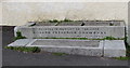
Crawshay Memorial in Gilwern
Located here http://www.geograph.org.uk/photo/5497602 the granite trough was erected in memory of the late Richard Frederick Crawshay of Ty Mawr by his widow in July 1908. Born in Cyfarthfa Castle in 1859, Richard Frederick Crawshay was a member of a family of industrialists and ironmasters in South Wales. He died in 1903.
Image: © Jaggery
Taken: 20 Aug 2017
0.01 miles
4
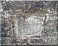
Ordnance Survey Cut Mark
This OS cut mark can be found on the wall at the rear of the Beaufort Arms. It marks a point 102.308m above mean sea level.
Image: © Adrian Dust
Taken: 6 Jul 2020
0.01 miles
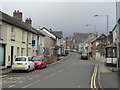
6
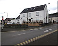
Houses, cars and diversion signs, Main Road, Gilwern
Diversion signs are in place on Sunday August 13th 2017
because the nearby A465 Heads of the Valleys Road is closed
between Gilwern and Brynmawr today during ongoing major roadworks.
The A465 is scheduled to reopen tomorrow.
Image: © Jaggery
Taken: 13 Aug 2017
0.01 miles
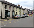
7
Wesley House, Main Road, Gilwern
In August 2017, Wesley House is the premises of Hannah Mlatem unisex hairdressing
salon on the ground floor and Smoulder Viola Academy & Clinic on the first floor.
Image: © Jaggery
Taken: 13 Aug 2017
0.01 miles
8
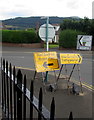
Green Man direction sign, Crickhowell Road, Gilwern
The Welsh/English temporary sign is in place on Sunday August 13th 2017.
This year the Green Man music and arts festival in the Brecon Beacons is from August 17th-20th.
Image: © Jaggery
Taken: 13 Aug 2017
0.02 miles
9
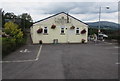
Gilwern Village Hall
Set back from Crickhowell Road, the hall extends away from the camera for 25 metres (about 80 feet).
The hall is also known as Gilwern War Memorial Hall. The village War Memorial http://www.geograph.org.uk/photo/5521042 is on the right.
Image: © Jaggery
Taken: 13 Aug 2017
0.02 miles
10
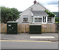
Two telecoms cabinets, Crickhowell Road, Gilwern
BT cabinet on the left, Virgin Media cabinet on the right.
Image: © Jaggery
Taken: 13 Aug 2017
0.02 miles