IMAGES TAKEN NEAR TO
High Trees Road, ABERGAVENNY, NP7 0AF
Introduction
This page details the photographs taken nearby to High Trees Road, NP7 0AF by members of the Geograph project.
The Geograph project started in 2005 with the aim of publishing, organising and preserving representative images for every square kilometre of Great Britain, Ireland and the Isle of Man.

There are currently over 7.5m images from over14,400 individuals and you can help contribute to the project by visiting https://www.geograph.org.uk
Image Map
Images are licensed for reuse under creativecommons.org/licenses/by-sa/2.0
Notes
- Clicking on the map will re-center to the selected point.
- The higher the marker number, the further away the image location is from the centre of the postcode.
Image Listing (148 Images Found)
Images are licensed for reuse under creativecommons.org/licenses/by-sa/2.0
Image
Details
Distance
1
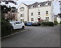
Coed Uchel, High Trees Road, Gilwern
Managed by United Welsh Housing Association, Coed Uchel is age exclusive housing
containing 44 flats built in 1989. New residents must be at least 55 years old.
Image: © Jaggery
Taken: 20 Aug 2017
0.01 miles
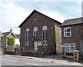
2
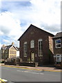
Hope Baptist Chapel
Gilwern's Hope Baptist Chapel, built in 1878.
Image: © David Roberts
Taken: 13 Jun 2009
0.01 miles
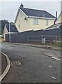
3
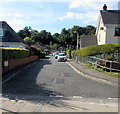
High Trees Road, Gilwern
Viewed across the A4077. The High Trees Road junction is where
the A4077 is Abergavenny Road on the left and Main Road on the right.
Image: © Jaggery
Taken: 13 Aug 2017
0.03 miles
4
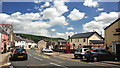
Main Road Gilwern
Main Road Gilwern, the High Street of this small village,taken on a sunny Summer day. This used to form part of the main trunk road from Abergavenny to Brynmawr. Prior to the construction of the A465 Heads of the Valley in 1965, this road was very heavily congested. Very similar to http://www.geograph.org.uk/photo/1417325
Image: © RAY JONES
Taken: 13 Jun 2009
0.04 miles
5
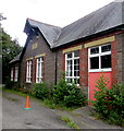
Former canalside primary school, Gilwern
Dated 1912, the building on the north bank of the Monmouthshire & Brecon Canal
is at the eastern end of the cul-de-sac School Lane, accessed from Main Road.
Image: © Jaggery
Taken: 13 Aug 2017
0.04 miles
6
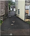
Towards a medical surgery, Gilwern, Monmouthshire
The surgery in the background is about 30 metres south of the A4077.
Image: © Jaggery
Taken: 17 Sep 2023
0.04 miles
7
Main Road houses, Gilwern
Viewed across the A4077, here named Main Road.
Image: © Jaggery
Taken: 13 Aug 2017
0.04 miles
8
Parish Centre, Abergavenny Road, Gilwern
Viewed from High Trees Road. I don't know the correct church terminology, but in layman's terms this is a sub-church or sister church of St Elli's church http://www.geograph.org.uk/photo/364419 at Llanelly (Monmouthshire).
Image: © Jaggery
Taken: 20 Oct 2010
0.04 miles
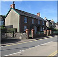
9
Hightrees Road house, Gilwern, Monmouthshire
Viewed looking south from the A4077 Abergavenny Road.
Image: © Jaggery
Taken: 17 Sep 2023
0.05 miles
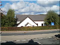
10
Hope Centre, Gilwern
Hope Centre, built in 1876 as Hope Baptist Chapel, is home to Hope Church.
Image: © Jaggery
Taken: 7 Jun 2013
0.05 miles