IMAGES TAKEN NEAR TO
Oakfield Terrace, Varteg Road, PONTYPOOL, NP4 9DS
Introduction
This page details the photographs taken nearby to Oakfield Terrace, Varteg Road, NP4 9DS by members of the Geograph project.
The Geograph project started in 2005 with the aim of publishing, organising and preserving representative images for every square kilometre of Great Britain, Ireland and the Isle of Man.

There are currently over 7.5m images from over14,400 individuals and you can help contribute to the project by visiting https://www.geograph.org.uk
Image Map
Images are licensed for reuse under creativecommons.org/licenses/by-sa/2.0
Notes
- Clicking on the map will re-center to the selected point.
- The higher the marker number, the further away the image location is from the centre of the postcode.
Image Listing (429 Images Found)
Images are licensed for reuse under creativecommons.org/licenses/by-sa/2.0
Image
Details
Distance
1
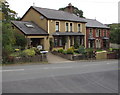
Oakfield Terrace, Varteg Road, Blaenavon
Viewed from the corner of Sycamore Road. Oakfield B&B (bed and breakfast accommodation) is on the left.
Image: © Jaggery
Taken: 20 Sep 2015
0.00 miles
2
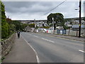
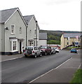
Down Varteg Road, Blaenavon
The B4246 Varteg Road descends towards the centre of Blaenavon. In September 2015, a banner on the right states that new homes in the Woodland View development will be available soon.
Image: © Jaggery
Taken: 20 Sep 2015
0.02 miles
3
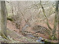
Small tributary of the Afon Lwyd, Blaenavon
An unnamed stream, having passed under Varteg Road, flows through a narrow wooded area towards the Afon Lwyd, about 100 metres away.
Image: © Jaggery
Taken: 3 Apr 2011
0.02 miles
4
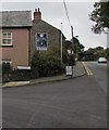
Corner of Varteg Road and Sycamore Road, Blaenavon
The bilingual name sign facing the B4246 Varteg Road
shows that Sycamore Road is Heol y Sycamorwydd in Welsh.
Image: © Jaggery
Taken: 20 Sep 2015
0.03 miles
5
Sycamore Road, Blaenavon
East of the B4246 Varteg Road.
Image: © Jaggery
Taken: 20 Sep 2015
0.03 miles
6
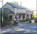
Oakfield B&B, Blaenavon
Nearest the camera is Oakfield B&B (bed and breakfast accommodation), which occupies two early 20th century houses that have been combined into one property. It is part of Oakfield Terrace, built by a local farmer as four properties alongside Varteg Road to house members of his family.
Image: © Jaggery
Taken: 25 Oct 2010
0.05 miles
7
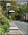
Sycamore Road bus stop and shelter, Blaenavon
Alongside the B4246 Varteg Road opposite Sycamore Road.
Image: © Jaggery
Taken: 20 May 2023
0.05 miles
8
Jogging up Varteg Road, Blaenavon
Heading away from Blaenavon, a jogger ascends the pavement on the east side of the B4246 Varteg Road.
A railway bridge https://www.geograph.org.uk/photo/5795349 is in the background.
Image: © Jaggery
Taken: 20 Sep 2015
0.05 miles
9
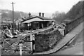
Blaenavon (Low Level) Station (remains)
View SE, towards Pontypool and Newport; terminus of GW line from Newport via Pontypool, closed completely 30/4/62. The station seems quite intact three years later.
Image: © Ben Brooksbank
Taken: 5 Apr 1965
0.06 miles
10
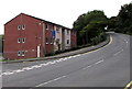
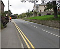
Varteg Road, Blaenavon
The B4246 Varteg Road ascends past Riverside Drive houses.
The dark blue sign shows a low bridge (headroom 4.19 metres/13' 9") 340 yards ahead.
What is now Riverside Drive and the adjacent area was formerly the site of Blaenavon (Low Level) Station. http://www.geograph.org.uk/photo/1825303
Image: © Jaggery
Taken: 20 Sep 2015
0.06 miles