IMAGES TAKEN NEAR TO
D Row, PONTYPOOL, NP4 9DG
Introduction
This page details the photographs taken nearby to D Row, NP4 9DG by members of the Geograph project.
The Geograph project started in 2005 with the aim of publishing, organising and preserving representative images for every square kilometre of Great Britain, Ireland and the Isle of Man.

There are currently over 7.5m images from over14,400 individuals and you can help contribute to the project by visiting https://www.geograph.org.uk
Image Map
Images are licensed for reuse under creativecommons.org/licenses/by-sa/2.0
Notes
- Clicking on the map will re-center to the selected point.
- The higher the marker number, the further away the image location is from the centre of the postcode.
Image Listing (76 Images Found)
Images are licensed for reuse under creativecommons.org/licenses/by-sa/2.0
Image
Details
Distance
1
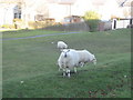
Forgeside Village Sheep
Sheep nibbling grass and posing for the camera in Forgeside village.
Image: © David Roberts
Taken: 21 Feb 2009
0.02 miles
2
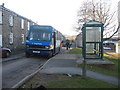
Forgeside Bus Stop
A bus stop by terraced houses in Forgeside, on the last day the bus service was operated by Stagecoach.
Image: © David Roberts
Taken: 21 Feb 2009
0.03 miles
3
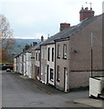
C Row houses, Forgeside, Blaenavon
The houses were built in 1850s for workers at the nearby ironworks and pits.
Row D and Row E http://www.geograph.org.uk/photo/2850333 survive, but A Row and B Row were demolished in the 1970s.
Image: © Jaggery
Taken: 15 Apr 2011
0.03 miles
4
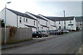
East side of Griffiths Court, Forgeside, Blaenavon
The houses are built on the site of A Row, demolished in the 1970s. A Row was one of five rows of houses built in the 1850s for workers at the nearby ironworks and pits. B Row was demolished at the same time, but C Row http://www.geograph.org.uk/photo/2850617 D Row and E Row http://www.geograph.org.uk/photo/2850333 survive.
Image: © Jaggery
Taken: 15 Apr 2011
0.04 miles
5
West side of Griffiths Court, Forgeside, Blaenavon
Griffiths Court houses occupy the site of A Row and B Row, which were rows of houses built in the 1850s for workers at the nearby ironworks and pits. C Row http://www.geograph.org.uk/photo/2850617 D Row and E Row http://www.geograph.org.uk/photo/2850333 survive.
Image: © Jaggery
Taken: 15 Apr 2011
0.04 miles
6
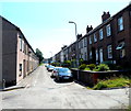
E Row houses, Forgeside, Blaenavon
The houses were built in 1850s for workers at the nearby ironworks and pits.
Anyone unfamiliar with the area would be confused to find houses numbered 1,2,3 etc on both sides of the street. The explanation is that the rows of houses are named, not the street itself.
These are houses on E Row, numbered from 17 to 1 in increasing distance from the camera. They face houses out of shot on the left in D Row, numbered 16 to 1. C Row survives, http://www.geograph.org.uk/photo/2850617 but A Row and B Row were demolished in the 1970s.
Image: © Jaggery
Taken: 15 Apr 2011
0.04 miles
7
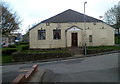
Forgeside Welfare Hall, Blaenavon
The Welfare Hall is located between Martin Terrace and Coity Terrace. The stone inscription on the wall above the doorway shows that hall dates from 1934.
Image: © Jaggery
Taken: 15 Apr 2011
0.04 miles
8
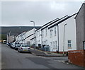
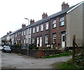
D row and E row houses, Forgeside
The rows of houses are named, not the street. D Row is on the left, E Row is on the right.
Image: © Jaggery
Taken: 22 Jul 2012
0.04 miles
9
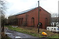
Disused electricity power house, C Row
Former power house built about 1920 for nearby ironworks, Forge Side. Compare with Image in 2011.
Image: © M J Roscoe
Taken: 6 Jan 2023
0.04 miles
10
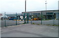
Industrial area, Forgeside, Blaenavon
A view through the fence, from a bend in Forge Road.
Industrial buildings extend for about 600 metres on the north side of the residential area of Forgeside.
Image: © Jaggery
Taken: 15 Apr 2011
0.05 miles