IMAGES TAKEN NEAR TO
Forgeside Road, PONTYPOOL, NP4 9DA
Introduction
This page details the photographs taken nearby to Forgeside Road, NP4 9DA by members of the Geograph project.
The Geograph project started in 2005 with the aim of publishing, organising and preserving representative images for every square kilometre of Great Britain, Ireland and the Isle of Man.

There are currently over 7.5m images from over14,400 individuals and you can help contribute to the project by visiting https://www.geograph.org.uk
Image Map
Images are licensed for reuse under creativecommons.org/licenses/by-sa/2.0
Notes
- Clicking on the map will re-center to the selected point.
- The higher the marker number, the further away the image location is from the centre of the postcode.
Image Listing (95 Images Found)
Images are licensed for reuse under creativecommons.org/licenses/by-sa/2.0
Image
Details
Distance
1
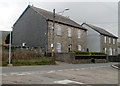
Detached houses, Forge Road, Forgeside
The house on the right was formerly the Forgeside Inn.
Image: © Jaggery
Taken: 15 Apr 2011
0.00 miles
2
Forgeside Road heads away from Forge Road, Forgeside
Forgeside Road heads NNE away from the eastern edge of the village of Forgeside.
Image: © Jaggery
Taken: 15 Apr 2011
0.00 miles
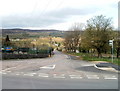
3

Corner of Forgeside Road and Forge Road, Forgeside
Forgeside Road, which connects with Varteg Road about 800 metres behind the camera, bends to the right here. The road on the left, which heads into the central area of Forgeside village, is Forge Road.
In view is the eastern edge of a factory.
Image: © Jaggery
Taken: 15 Apr 2011
0.00 miles
4
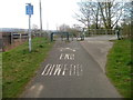
End of cycle route, Forgeside Road, Forgeside
The connecting cycleway from National Cycle Network route 46 to Forgeside Road ends at the edge of the road. Sturdy metal barriers and a locked metal gate prevent inappropriate vehicles entering the cycleway from Forgeside Road.
Image: © Jaggery
Taken: 15 Apr 2011
0.00 miles
6
End of bridleway at Forge Side Road
The path goes up behind the camera to the top of Coety Mountain.
Image: © M J Roscoe
Taken: 6 Jan 2023
0.03 miles
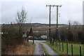
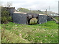
7
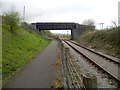
Forgeside Road bridge across the railway, Forgeside
View from National Cycle Network route 46 http://www.geograph.org.uk/photo/2849538 which here runs parallel with the single-track line of the heritage Pontypool & Blaenavon Railway. The bridge has a weight restriction. http://www.geograph.org.uk/photo/2363712
Image: © Jaggery
Taken: 15 Apr 2011
0.06 miles
8
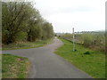
Path junction, Forgeside
To the west of the railway bridge http://www.geograph.org.uk/photo/2849567 a path on the left heads away from National Cycle Network route 46 towards Forgeside Road.
Image: © Jaggery
Taken: 15 Apr 2011
0.06 miles
9
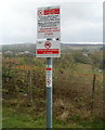
Notices at a path junction, Forgeside
The post carrying three notices is located facing this http://www.geograph.org.uk/photo/2849602 path junction.
One notices warns of a maximum fine of £1,000 for "not cleaning up after your dog."
Another notice states that there is a "temporary prohibition of horses" but does not
state why or for how long. It shows a phone number to ring for more information.
Image: © Jaggery
Taken: 15 Apr 2011
0.06 miles
10
Reinforced bridge arch, Forgeside Road, Forgeside
Metal plates reinforce an arch carrying Forgeside Road, on the north side of the main bridge. http://www.geograph.org.uk/photo/2363764
Image: © Jaggery
Taken: 15 Apr 2011
0.06 miles