IMAGES TAKEN NEAR TO
Twyngwyn, PONTYPOOL, NP4 8TS
Introduction
This page details the photographs taken nearby to Twyngwyn, NP4 8TS by members of the Geograph project.
The Geograph project started in 2005 with the aim of publishing, organising and preserving representative images for every square kilometre of Great Britain, Ireland and the Isle of Man.

There are currently over 7.5m images from over14,400 individuals and you can help contribute to the project by visiting https://www.geograph.org.uk
Image Map
Images are licensed for reuse under creativecommons.org/licenses/by-sa/2.0
Notes
- Clicking on the map will re-center to the selected point.
- The higher the marker number, the further away the image location is from the centre of the postcode.
Image Listing (10 Images Found)
Images are licensed for reuse under creativecommons.org/licenses/by-sa/2.0
Image
Details
Distance
1
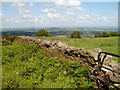
Dry stone wall on high ground NE of Pontypool
The wall is near this gate. http://www.geograph.org.uk/photo/3419727
Image: © Jaggery
Taken: 7 Jun 2011
0.16 miles
2
Lane to Tir-croes Bleddyn Farm east of Trevethin, Pontypool
Viewed from Folly Lane.
Image: © Jaggery
Taken: 7 Jun 2011
0.16 miles
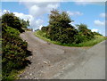
3
Upland lane above Pontypool
The lane on the crown of the ridge here.
Image: © Jeremy Bolwell
Taken: 18 Nov 2012
0.17 miles
4
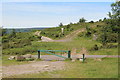
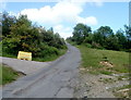
Gate to car park, Folly Lane
The green gate to the car park, foreground, has been locked. On the other side of the road, the lane on the left leads to Coed Ithel Image The rough track to the right leads also to Coed Ithel along the upper eastern boundary of Little Mountain.
Image: © M J Roscoe
Taken: 7 Aug 2020
0.17 miles
5
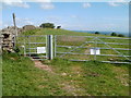
Gate leading to a track to the Folly Tower NE of Pontypool
Viewed from Folly Lane. The 300 metre long track leads to this folly tower. http://www.geograph.org.uk/photo/3419691
A Torfaen County Borough Council notice on the gate states:
Public footpath only. Private land, please keep dogs on a lead when stock is in field.
Image: © Jaggery
Taken: 7 Jun 2011
0.18 miles
6
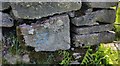
Ordnance Survey Cut Mark
This OS cut mark can be found at the entrance to the track leading to the Folly. It marks a point 293.580m above mean sea level.
Image: © Adrian Dust
Taken: 27 Jun 2019
0.18 miles
7
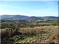
Upland overlooking Trevethin and Pontypool
The industrialised valleys below are now ameliorated and blended into the landscape with attractive moorland above.
Image: © Jeremy Bolwell
Taken: 18 Nov 2012
0.19 miles
8
Towards top of Folly lane from Folly Tower
The public footpath down from the tower meets the lane Image to the right of the line of bushes.]
Image: © M J Roscoe
Taken: 7 Aug 2020
0.20 miles
9
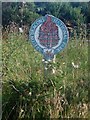
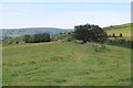
Brecon Beacons National Park sign
This rather ancient sign is near the end of the minor road that climbs up the central ridge in this square from Pontypool. The ridge is the western boundary of the narrow southeastern appendage of the National Park.
Image: © Rudi Winter
Taken: 8 Aug 2005
0.21 miles
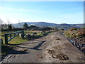
10
Folly Lane passes a side road to a covered reservoir east of Trevethin, Pontypool
The edge of the covered reservoir is about 100 metres along the side road.
Image: © Jaggery
Taken: 7 Jun 2011
0.25 miles