IMAGES TAKEN NEAR TO
George Street, PONTYPOOL, NP4 8PA
Introduction
This page details the photographs taken nearby to George Street, NP4 8PA by members of the Geograph project.
The Geograph project started in 2005 with the aim of publishing, organising and preserving representative images for every square kilometre of Great Britain, Ireland and the Isle of Man.

There are currently over 7.5m images from over14,400 individuals and you can help contribute to the project by visiting https://www.geograph.org.uk
Image Map
Images are licensed for reuse under creativecommons.org/licenses/by-sa/2.0
Notes
- Clicking on the map will re-center to the selected point.
- The higher the marker number, the further away the image location is from the centre of the postcode.
Image Listing (136 Images Found)
Images are licensed for reuse under creativecommons.org/licenses/by-sa/2.0
Image
Details
Distance
1
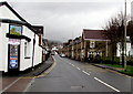
Bus stop opposite the Royal Oak, Pontnewynydd
On the B4246 opposite this http://www.geograph.org.uk/photo/4767230 pub.
Image: © Jaggery
Taken: 17 Dec 2015
0.01 miles
2
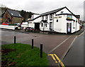
Royal Oak, Pontnewynydd
Pub alongside the B4246. Some maps show this location as the southern end of Freeholdland Road
whereas the pub's website states (the northern end of) George Street.
Image: © Jaggery
Taken: 17 Dec 2015
0.01 miles
3
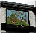
Royal Oak name sign, Pontnewynydd
On a corner of this http://www.geograph.org.uk/photo/4767230 pub. The faded gold lettering at the bottom of the sign formerly showed USHERS.
Image: © Jaggery
Taken: 17 Dec 2015
0.01 miles
4
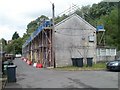
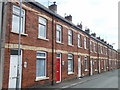
Reroofing in progress, River Row, Pontnewynydd
Scaffolding covers the 60 metre length of River Row during work on the roofs. River Row is on the west bank of the Afon Lwyd.
Image: © Jaggery
Taken: 9 May 2011
0.03 miles
5
Afon Llwyd Terrace, Pontnewynydd
Houses on the southern half of Afon Llwyd Terrace.
Strangely, in English both Afon Lwyd and Afon Llwyd are used for the name of the nearby river, but the correct Welsh form is Afon Lwyd (Grey River).
Image: © Jaggery
Taken: 9 May 2011
0.03 miles
6
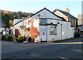
The Royal Oak, Pontnewynydd
Pub alongside the B4246. Some maps show this location as the southern end of Freeholdland Road whereas the pub's website states (the northern end of) George Street.
Image: © Jaggery
Taken: 25 Oct 2010
0.03 miles
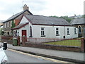
7
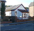
Emmaus Chapel, Pontnewynydd
Located on Freeholdland Road. The chapel is one of 35 chapels or churches in Wales which are affiliated to the Congregational Federation. On the left is Chapel House. http://www.geograph.org.uk/photo/2127916
Image: © Jaggery
Taken: 25 Oct 2010
0.03 miles
8
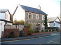
Chapel House, Pontnewynydd
Located on Freeholdland Road. Emmaus Chapel http://www.geograph.org.uk/photo/2127907 is on the right.
Image: © Jaggery
Taken: 25 Oct 2010
0.03 miles
9
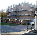
Belle Vue Court, Pontnewynydd
Located on George Street. One of several flats buildings in the area that were encased in scaffolding at the end of October 2010. On the right is the edge of The Royal Oak pub. http://www.geograph.org.uk/photo/2127888
Image: © Jaggery
Taken: 25 Oct 2010
0.03 miles
10
Emmaus Chapel, Pontnewynydd
Located on Freeholdland Road. The chapel is one of 35 chapels or churches in Wales which are affiliated to the Congregational Federation. On the left is Chapel House. http://www.geograph.org.uk/photo/2127916
Image: © Jaggery
Taken: 9 May 2011
0.03 miles