IMAGES TAKEN NEAR TO
Afon Llwyd Terrace, PONTYPOOL, NP4 8LX
Introduction
This page details the photographs taken nearby to Afon Llwyd Terrace, NP4 8LX by members of the Geograph project.
The Geograph project started in 2005 with the aim of publishing, organising and preserving representative images for every square kilometre of Great Britain, Ireland and the Isle of Man.

There are currently over 7.5m images from over14,400 individuals and you can help contribute to the project by visiting https://www.geograph.org.uk
Image Map
Images are licensed for reuse under creativecommons.org/licenses/by-sa/2.0
Notes
- Clicking on the map will re-center to the selected point.
- The higher the marker number, the further away the image location is from the centre of the postcode.
Image Listing (105 Images Found)
Images are licensed for reuse under creativecommons.org/licenses/by-sa/2.0
Image
Details
Distance
1
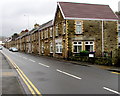
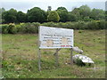
Torfaen Terrace, Pontnewynydd
Long row of houses on the east side of the B4246 Freeholdland Road.
Image: © Jaggery
Taken: 17 Dec 2015
0.03 miles
2
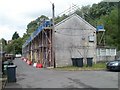
Reroofing in progress, River Row, Pontnewynydd
Scaffolding covers the 60 metre length of River Row during work on the roofs. River Row is on the west bank of the Afon Lwyd.
Image: © Jaggery
Taken: 9 May 2011
0.05 miles
3
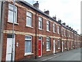
Afon Llwyd Terrace, Pontnewynydd
Houses on the southern half of Afon Llwyd Terrace.
Strangely, in English both Afon Lwyd and Afon Llwyd are used for the name of the nearby river, but the correct Welsh form is Afon Lwyd (Grey River).
Image: © Jaggery
Taken: 9 May 2011
0.05 miles
4
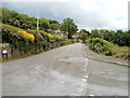
Leigh Road, Pontnewynydd
Lower Leigh Road behind the camera becomes Leigh Road ahead, on passing the right turn for Hospital Road.
Image: © Jaggery
Taken: 9 May 2011
0.06 miles
5
Abandoned housing development, Hospital Road, Pontnewynydd
A battered board announces a housing development on a triangle of land between Hospital Road and Leigh Road. Presumably the development was a victim of the credit crunch. The site is mostly weeds, and some pipes. http://www.geograph.org.uk/photo/2412335
Image: © Jaggery
Taken: 9 May 2011
0.06 miles
6
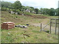
Pipes on an abandoned housing development site, Hospital Road, Pontnewynydd
A battered sign http://www.geograph.org.uk/photo/2412331 and some pipes are all that remain of an abandoned housing development project on a triangle of land between Hospital Road and Leigh Road.
Image: © Jaggery
Taken: 9 May 2011
0.06 miles
7
Towards Machine Meadow houses, Pontnewynydd
From the edge of the A4043 St Luke's Road.
Image: © Jaggery
Taken: 17 Dec 2015
0.08 miles
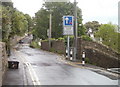
8
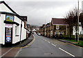
Bus stop opposite the Royal Oak, Pontnewynydd
On the B4246 opposite this http://www.geograph.org.uk/photo/4767230 pub.
Image: © Jaggery
Taken: 17 Dec 2015
0.08 miles
9
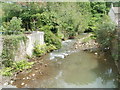
Afon Lwyd flows away from Freeholdland Road, Pontnewynydd
Viewed from the B4246 road bridge at the northern end of Torfaen Terrace. http://www.geograph.org.uk/photo/2402499
Image: © Jaggery
Taken: 9 May 2011
0.08 miles
10
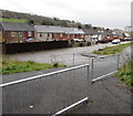
Lower Leigh Road, Pontnewynydd
Viewed from the edge of a row of houses. http://www.geograph.org.uk/photo/2412244
The sloping wall on the right is at the edge of a steps http://www.geograph.org.uk/photo/2412267 to a path descending towards Freeholdland Road.
Image: © Jaggery
Taken: 9 May 2011
0.08 miles