IMAGES TAKEN NEAR TO
Old Penygarn, PONTYPOOL, NP4 8JU
Introduction
This page details the photographs taken nearby to NP4 8JU by members of the Geograph project.
The Geograph project started in 2005 with the aim of publishing, organising and preserving representative images for every square kilometre of Great Britain, Ireland and the Isle of Man.

There are currently over 7.5m images from over14,400 individuals and you can help contribute to the project by visiting https://www.geograph.org.uk
Image Map
Images are licensed for reuse under creativecommons.org/licenses/by-sa/2.0
Notes
- Clicking on the map will re-center to the selected point.
- The higher the marker number, the further away the image location is from the centre of the postcode.
Image Listing (56 Images Found)
Images are licensed for reuse under creativecommons.org/licenses/by-sa/2.0
Image
Details
Distance
1
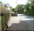
No footway for 30 yards, Penygarn Road, Pontypool
Fortunately there is a footpath http://www.geograph.org.uk/photo/2429907 along the perimeter of Penygarn Infants School which gives a safe alternative route for walkers.
Image: © Jaggery
Taken: 27 May 2011
0.04 miles
2
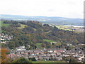
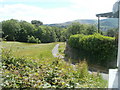
Over Pontypool Park
Over the park to Llanegfedd Reservoir from Pentranch.
Image: © brian walker
Taken: 24 Oct 2008
0.04 miles
3
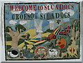
Welcome to St Cadocs mosaic
The mosaic is on the side of lock-up garages at the southern end of St Cadoc's Road. http://www.geograph.org.uk/photo/2430851
St Cadocs is a small community in NE Pontypool, adjacent to Penygarn and Trevethin.
Image: © Jaggery
Taken: 27 May 2011
0.06 miles
4
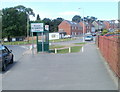
Welcome to St Cadocs
The sign is on the side of Penygarn Road, at the St Cadoc's Road turning (on the right). The community of St Cadocs is in NE Pontypool, adjacent to Penygarn and Trevethin.
The ancient church of St Cadoc is nearby.
Image: © Jaggery
Taken: 27 May 2011
0.06 miles
5
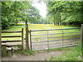
Pontypool : entrance from Penygarn Road to a field
A stile and gate are at the Penygarn Road side of a field to the east of Penygarn Infants School. http://www.geograph.org.uk/photo/2429898
Image: © Jaggery
Taken: 1 Jun 2011
0.10 miles
6
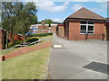
Southern side of Penygarn Infants School, Pontypool
Viewed from a footpath along the school's perimeter.
Image: © Jaggery
Taken: 27 May 2011
0.10 miles
7
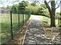
Footpath along perimeter fence of Penygarn Infants School
The footpath is a safe alternative to Penygarn Road, which is without pavements for about 30 metres. http://www.geograph.org.uk/photo/2429915
Image: © Jaggery
Taken: 27 May 2011
0.10 miles
8
Path to Old Penygarn
A path heads south away from the Yew Tree Italian Restaurant http://www.geograph.org.uk/photo/2431149 Trevethin.
Image: © Jaggery
Taken: 27 May 2011
0.10 miles
9
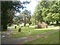
Path junction, St Cadoc's churchyard
The churchyard occupies a large site, more than 200 metres by 200 metres at its widest, on the north side of Penygarn Road, between Trevethin and the community of St Cadocs, NE Pontypool. The church http://www.geograph.org.uk/photo/2430897 is about 100 metres away, ahead.
Image: © Jaggery
Taken: 27 May 2011
0.11 miles
10
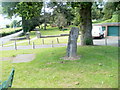
Oak sculpture, Trevethin
The sculpture is underneath an oak http://www.geograph.org.uk/photo/2438331 on the north side of Penygarn Road.
In the background is an entrance http://www.geograph.org.uk/photo/2430919 to St Cadoc's churchyard.
Image: © Jaggery
Taken: 27 May 2011
0.11 miles