IMAGES TAKEN NEAR TO
Leigh Road, PONTYPOOL, NP4 8JF
Introduction
This page details the photographs taken nearby to Leigh Road, NP4 8JF by members of the Geograph project.
The Geograph project started in 2005 with the aim of publishing, organising and preserving representative images for every square kilometre of Great Britain, Ireland and the Isle of Man.

There are currently over 7.5m images from over14,400 individuals and you can help contribute to the project by visiting https://www.geograph.org.uk
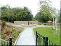
Image Map
Images are licensed for reuse under creativecommons.org/licenses/by-sa/2.0
Notes
- Clicking on the map will re-center to the selected point.
- The higher the marker number, the further away the image location is from the centre of the postcode.
Image Listing (76 Images Found)
Images are licensed for reuse under creativecommons.org/licenses/by-sa/2.0
Image
Details
Distance
1
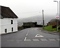
Leigh Road from Trevethin towards Pontnewynydd
Viewed across Church Avenue at the southern edge of Trevethin.
Image: © Jaggery
Taken: 5 Dec 2016
0.01 miles
2
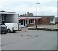
Spar, Trevethin, Pontypool
Location at the southern end of a small shopping area on Church Avenue. Trevethin Post Office http://www.geograph.org.uk/photo/2448720 is at the northern end of the area. In the distance is the top of the tower of St Cadoc's church. http://www.geograph.org.uk/photo/2430897
Image: © Jaggery
Taken: 1 Jun 2011
0.02 miles
3
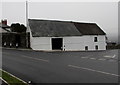
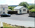
White house on a St Cadocs corner
On the corner of Church Avenue and Leigh Road, a few metres south of the Trevethin boundary signs. http://www.geograph.org.uk/photo/5218642
Image: © Jaggery
Taken: 5 Dec 2016
0.02 miles
4
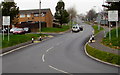
Southern boundary of Trevethin, Torfaen
The boundary signs facing the southern end of Church Avenue show that Trevethin is Trefddyn in Welsh. Formerly a small village that was the seat of the parish of Trevethin in the ancient Abergavenny Hundred, Trevethin is now a suburb in the north of Pontypool. Trevethin's population was 5,147 on the day of UK National Census in April 2011.
Image: © Jaggery
Taken: 5 Dec 2016
0.04 miles
5

Trevethin Police Station
The blue door is the entrance to the police station, which occupies the eastern end of a Trevethin Housing Offices building, located to the east of Church Avenue and south of Folly Road, facing the community centre. http://www.geograph.org.uk/photo/2448573
Image: © Jaggery
Taken: 1 Jun 2011
0.04 miles
6
Trevethin Community Garden and beacon, Pontypool
The Community Garden, located between Folly Lane and Folly Road, was officially opened in July 2009. Its focal point is a beacon which was originally erected in the Folly Tower car park and lit on New Year’s Eve 1993. It was later moved to the grounds of Trevethin Community School. After the school's closure in 2007, the beacon was stored in Pontypool Museum before installation here.
Image: © Jaggery
Taken: 1 Jun 2011
0.04 miles
7
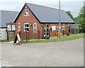
Communities First Resource Centre, Trevethin
Located opposite Trevethin Community Garden.
Communities First is a Welsh Assembly Government programme aimed at improving the living conditions and prospects of people in disadvantaged communities in Wales.
Image: © Jaggery
Taken: 1 Jun 2011
0.04 miles
8
Tea Time, Trevethin
A former betting office next door to the Yew Tree Italian Restaurant http://www.geograph.org.uk/photo/2431149 has been converted to the Yew Tree's tea and coffee shop, now named Tea Time.
Image: © Jaggery
Taken: 27 May 2011
0.04 miles
9
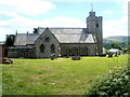
North side of St Cadoc's church, Trevethin
Viewed from Folly Lane. The church is at the SW edge of a site containing a large graveyard. The site is roughly 230 metres west to east and 200 metres north to south. An information board states that the church dates from the 12th century. It was Grade II listed in 1962.
Image: © Jaggery
Taken: 27 May 2011
0.04 miles
10
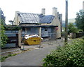
Major renovation work, Mason's Arms, Trevethin
Viewed across Folly Lane. The major work on this side of the building contrasts with the view of the opposite side. http://www.geograph.org.uk/photo/2429956 Whether the pub will reopen, or the building will have a different use in the future, is unknown to this contributor.
Image: © Jaggery
Taken: 27 May 2011
0.04 miles