IMAGES TAKEN NEAR TO
Garth Close, PONTYPOOL, NP4 8EH
Introduction
This page details the photographs taken nearby to Garth Close, NP4 8EH by members of the Geograph project.
The Geograph project started in 2005 with the aim of publishing, organising and preserving representative images for every square kilometre of Great Britain, Ireland and the Isle of Man.

There are currently over 7.5m images from over14,400 individuals and you can help contribute to the project by visiting https://www.geograph.org.uk
Image Map
Images are licensed for reuse under creativecommons.org/licenses/by-sa/2.0
Notes
- Clicking on the map will re-center to the selected point.
- The higher the marker number, the further away the image location is from the centre of the postcode.
Image Listing (55 Images Found)
Images are licensed for reuse under creativecommons.org/licenses/by-sa/2.0
Image
Details
Distance
1
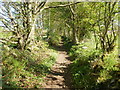
Stony path leading to Lasgarn Wood
A very stony path connects the northeast edge of Trevethin with Lasgarn Wood, a few metres ahead. Fields are on both sides of the fenced path at this point.
Image: © Jaggery
Taken: 12 May 2010
0.03 miles
2
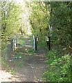
Entrance from Woodside Road, Trevethin to path into Lasgarn Wood
The entrance is at the northeast edge of Trevethin. The fenced path heads NNW through fields for about 200 metres before reaching the edge of the wood.
Image: © Jaggery
Taken: 12 May 2010
0.03 miles
3
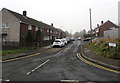
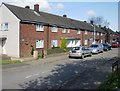
Y Garth/Garth Close, Trevethin
Cul-de-sac on the northwest side of Glen View Road.
A bilingual (English/Welsh) Garth Close/Y Garth name sign is on the right.
Image: © Jaggery
Taken: 5 Dec 2016
0.03 miles
4
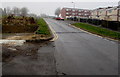
Site of the demolished The Moon pub, Trevethin
Viewed in December 2016. The site on the left, on the corner of Glen View Road and Garth Close,
was occupied by The Moon pub in this http://www.geograph.org.uk/photo/1853741 May 2010 photo.
Image: © Jaggery
Taken: 5 Dec 2016
0.04 miles
5
Garth Close, Trevethin
Viewed from the corner of Glen View Road.
Image: © Jaggery
Taken: 12 May 2010
0.04 miles
6
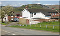
The Moon, Trevethin
Pub on the corner of Glen View Road and Garth Close, viewed in May 2010.
UPDATE. This December 2016 photo http://www.geograph.org.uk/photo/5217150 shows that the pub has been demolished.
Image: © Jaggery
Taken: 12 May 2010
0.04 miles
7
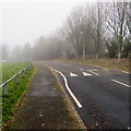
Into the fog, Woodside Road, Trevethin
Viewed on December 5th 2016, a day when the fog was much denser here at 275 metres (about 900 ft) above mean sea level, near the northern edge of Pontypool, than in lower-lying central Pontypool. A sign http://www.geograph.org.uk/photo/5218110 behind the camera warns of humps across the road for 200 yards ahead.
Image: © Jaggery
Taken: 5 Dec 2016
0.05 miles
8
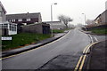
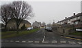
Up Glen View Road, Trevethin
Part of the long ascent along Glen View Road towards Woodside Road.
The bilingual name sign on the left shows that Glen View Road is Heol Trem y Glyn in Welsh.
Image: © Jaggery
Taken: 5 Dec 2016
0.05 miles
9
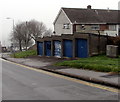
Five lockup garages and a telecoms cabinet, Trevethin
Alongside Glen View Road opposite Canford Close. http://www.geograph.org.uk/photo/5217108
Image: © Jaggery
Taken: 5 Dec 2016
0.05 miles
10
Barn Close, Trevethin
Cul-de-sac on the northwest side of Glen View Road.
The bilingual name sign on the right shows that Barn Close is Clos y Sgubor in Welsh.
Image: © Jaggery
Taken: 5 Dec 2016
0.05 miles