IMAGES TAKEN NEAR TO
Samsons Avenue, PONTYPOOL, NP4 7RY
Introduction
This page details the photographs taken nearby to Samsons Avenue, NP4 7RY by members of the Geograph project.
The Geograph project started in 2005 with the aim of publishing, organising and preserving representative images for every square kilometre of Great Britain, Ireland and the Isle of Man.

There are currently over 7.5m images from over14,400 individuals and you can help contribute to the project by visiting https://www.geograph.org.uk
Image Map (Loading...)


Getting Data...Please wait
Leaflet Map data © OpenStreetMap
Images are licensed for reuse under creativecommons.org/licenses/by-sa/2.0
Notes
- Clicking on the map will re-center to the selected point.
- The higher the marker number, the further away the image location is from the centre of the postcode.
Image Listing (99 Images Found)
Images are licensed for reuse under creativecommons.org/licenses/by-sa/2.0
Image
Details
Distance
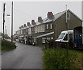
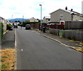
1
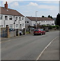
From Samson's Avenue towards Lasgarn View, Varteg
The house at the right end of the row is near the corner of the road named Lasgarn View.
Image: © Jaggery
Taken: 16 Jul 2018
0.03 miles
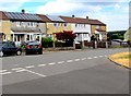
2

Lasgarn View houses, Varteg
Varteg is an upland village in the county borough of Torfaen, between Pontypool and Blaenavon.
Image: © Jaggery
Taken: 25 Sep 2015
0.04 miles
3
Samson's Avenue rooftop solar panels, Varteg
Viewed from the corner of Gwyn Crescent.
Image: © Jaggery
Taken: 16 Jul 2018
0.05 miles
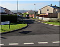
4
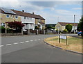
Junction of Gwyn Crescent and Samson's Avenue, Varteg
The bilingual name sign shows that Gwyn Crescent is Cilgant Gwyn in Welsh.
Image: © Jaggery
Taken: 16 Jul 2018
0.05 miles
5
Row of houses, Lasgarn View, Varteg
The row extends for 50 metres at the northern end of Lasgarn View. Viewed from the corner of Samson's Avenue.
Image: © Jaggery
Taken: 16 Jul 2018
0.05 miles
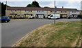
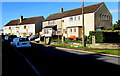
6
Gladstone Terrace, Varteg
Row of houses extending for 70 metres, set back from the east side of the B4246 Varteg Road.
Image: © Jaggery
Taken: 28 Jun 2017
0.05 miles
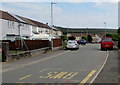
7
Gwyn Crescent, Varteg
Looking south from Samson's Avenue.
Image: © Jaggery
Taken: 25 Sep 2015
0.06 miles
8
East along Samson's Avenue, Varteg
Towards Garndiffaith. It was not clear to this visitor to the area exactly where Varteg ends
and Garndiffaith begins. Boundary signs https://www.geograph.org.uk/photo/4678607 show the names of both villages.
Image: © Jaggery
Taken: 16 Jul 2018
0.06 miles
9
Sunshine and shade in Varteg
Lasgarn View houses at 9am in late September.
Image: © Jaggery
Taken: 25 Sep 2015
0.06 miles
10
South along Gwyn Crescent, Varteg
From the corner of Samson's Avenue.
Image: © Jaggery
Taken: 16 Jul 2018
0.07 miles