IMAGES TAKEN NEAR TO
Pisgah Road, PONTYPOOL, NP4 7JE
Introduction
This page details the photographs taken nearby to Pisgah Road, NP4 7JE by members of the Geograph project.
The Geograph project started in 2005 with the aim of publishing, organising and preserving representative images for every square kilometre of Great Britain, Ireland and the Isle of Man.

There are currently over 7.5m images from over14,400 individuals and you can help contribute to the project by visiting https://www.geograph.org.uk
Image Map
Images are licensed for reuse under creativecommons.org/licenses/by-sa/2.0
Notes
- Clicking on the map will re-center to the selected point.
- The higher the marker number, the further away the image location is from the centre of the postcode.
Image Listing (124 Images Found)
Images are licensed for reuse under creativecommons.org/licenses/by-sa/2.0
Image
Details
Distance
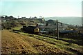
1
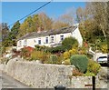
Houses at the southern end of High Street, Garndiffaith
Viewed from the junction of High Street and Viaduct Road. The southern end of High Street is more like a narrow country lane than a typical high street.
Image: © Jaggery
Taken: 25 Oct 2010
0.02 miles
2
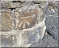
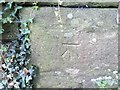
Ordnance Survey Cut Mark
This OS cut mark can be found on the wall at the road junction on Viaduct Road. It marks a point 237.308m above mean sea level.
Image: © Adrian Dust
Taken: 25 Aug 2019
0.05 miles
3
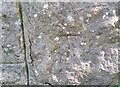
Ordnance Survey Cut Mark
This OS cut mark can be found on the wall NE side of High Street. It marks a point 246.976m above mean sea level.
Image: © Adrian Dust
Taken: 25 Aug 2019
0.06 miles
4
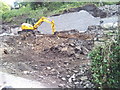
6 houses demolished, High Street, Garndiffaith
Image: © Alex McGregor
Taken: 6 Jun 2011
0.06 miles
5
Ordnance Survey Cut Mark
This OS cut mark can be found on the wall railway bridge. It marks a point 244.081m above mean sea level.
Image: © Adrian Dust
Taken: 25 Aug 2019
0.07 miles
6
Passing the site of Garndiffaith Junction ? 1969
Type 3 (Class 37) locomotive with a short train of mineral wagons descends the line from Big Pit, Blaenavon. This was the former LNWR Abersychan Extension branch, which had closed to general freight as early as 1954, and had subsequently been reduced to single track.
The junction, actually on the viaduct, was with industrial lines that came up the formation where the photographer is standing, serving a number of collieries on the western side of the valley as well as, originally, the British Iron Works. The line has been adapted to form a footpath and cycleway up the valley, and this view https://www.geograph.org.uk/photo/4679696 is taken at almost exactly the same location.
Image: © Alan Murray-Rust
Taken: 26 Nov 1969
0.08 miles
7
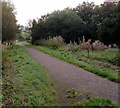
Path towards Nant Ffrwd, Talywain
Viewed from near this http://www.geograph.org.uk/photo/4679665 barrier. The stream Nant Ffrwd is a tributary of a river, the Afon Lwyd.
Image: © Jaggery
Taken: 29 Sep 2015
0.09 miles
8
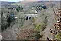
Garndiffaith Railway Viaduct
Curved viaduct of nine arches which originally carried the LNWR Abersychan Extension Branch and now carries NCR 492 over the River Ffrwd.
Image: © M J Roscoe
Taken: 25 Feb 2022
0.09 miles
9

Garndiffaith Viaduct from the north
The eastern side of the viaduct, viewed along Viaduct Road from near the High Street junction.
The brickwork viaduct was built in the 1870s to carry the Brynmawr and Blaenavon Railway across a valley and stream, from Garndiffaith in the east to Talywain in the west. It is about 200 metres long. Closed to passenger traffic in 1941, it remained in use for mineral traffic until 1980. The viaduct now carries National Cycle Route 46.
Image: © Jaggery
Taken: 25 Oct 2010
0.11 miles
10
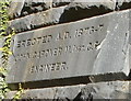
Tablet, Garndiffaith Viaduct
The tablet on the east side of the viaduct http://www.geograph.org.uk/photo/2137473 arch above Viaduct Road shows
ERECTED A.D. 1876-7
JOHN GARDNER M.INST.C.E.
ENGINEER
M.INST.C.E. indicates a Member of the Institution of Civil Engineers.
Image: © Jaggery
Taken: 25 Oct 2010
0.11 miles