IMAGES TAKEN NEAR TO
Cwrt Y Porth Fawr, PONTYPOOL, NP4 7EQ
Introduction
This page details the photographs taken nearby to Cwrt Y Porth Fawr, NP4 7EQ by members of the Geograph project.
The Geograph project started in 2005 with the aim of publishing, organising and preserving representative images for every square kilometre of Great Britain, Ireland and the Isle of Man.

There are currently over 7.5m images from over14,400 individuals and you can help contribute to the project by visiting https://www.geograph.org.uk
Image Map
Images are licensed for reuse under creativecommons.org/licenses/by-sa/2.0
Notes
- Clicking on the map will re-center to the selected point.
- The higher the marker number, the further away the image location is from the centre of the postcode.
Image Listing (105 Images Found)
Images are licensed for reuse under creativecommons.org/licenses/by-sa/2.0
Image
Details
Distance
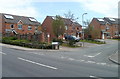
1
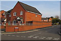
North side of Cwrt y Porth Fawr, Talywain
Part of an area of modern houses on the west side of the B4246 Church Road.
Image: © Jaggery
Taken: 29 Sep 2015
0.02 miles
2
West side of Cwrt y Porth Fawr, Talywain
Part of an area of modern houses on the west side of the B4246 Church Road.
Image: © Jaggery
Taken: 29 Sep 2015
0.02 miles
3
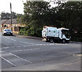
Scarab at work in Talywain
The Torfaen Borough Council Scarab vehicle is cleaning the corner of Church Road and Manor Road.
Image: © Jaggery
Taken: 29 Sep 2015
0.03 miles
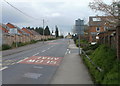
4
Church Road bus stop and shelter, Talywain
Near the southern edge of Talywain, between British School Close and Manor Road (ahead).
Image: © Jaggery
Taken: 29 Sep 2015
0.03 miles
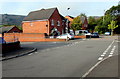
5
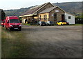
Former railway building in Talywain
Set back 100 metres from the B4246 Church Road, in September 2015 this is the premises of M.B. Evans Ltd,
(fabrications and welding). The business's address is Old Station Yard, Church Road.
Image: © Jaggery
Taken: 29 Sep 2015
0.04 miles
6
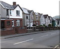
Church Road houses, Talywain
On the east side of the B4246 Church Road.
Image: © Jaggery
Taken: 29 Sep 2015
0.04 miles
7
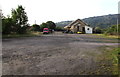
Old Station Yard, Talywain
The former railway yard is set back 100 metres from the west side of Church Road. In September 2015, the former railway building http://www.geograph.org.uk/photo/4681422 is the premises of M.B. Evans Ltd, (fabrications and welding).
Image: © Jaggery
Taken: 29 Sep 2015
0.04 miles
8
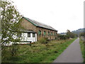
Former goods shed at Abersychan & Talywain
NCN route 46 now takes the place of the former railway line.
Image: © Gareth James
Taken: 15 Oct 2011
0.04 miles
9
British School Close, Abersychan
Modern houses at the northern edge of Abersychan, a few metres from the Talywain boundary. http://www.geograph.org.uk/photo/2372058
Image: © Jaggery
Taken: 16 Apr 2011
0.05 miles
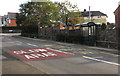
10
Southern boundary of Talywain
The B4246 leaves Abersychan and enters Talywain opposite the turning for British School Close. http://www.geograph.org.uk/photo/2372048
UPDATE In September 2015, Talywain's southern boundary signs http://www.geograph.org.uk/photo/4681559 are more than 100 metres further south.
Image: © Jaggery
Taken: 16 Apr 2011
0.05 miles