IMAGES TAKEN NEAR TO
Church Terrace, PONTYPOOL, NP4 6SL
Introduction
This page details the photographs taken nearby to Church Terrace, NP4 6SL by members of the Geograph project.
The Geograph project started in 2005 with the aim of publishing, organising and preserving representative images for every square kilometre of Great Britain, Ireland and the Isle of Man.

There are currently over 7.5m images from over14,400 individuals and you can help contribute to the project by visiting https://www.geograph.org.uk
Image Map
Images are licensed for reuse under creativecommons.org/licenses/by-sa/2.0
Notes
- Clicking on the map will re-center to the selected point.
- The higher the marker number, the further away the image location is from the centre of the postcode.
Image Listing (163 Images Found)
Images are licensed for reuse under creativecommons.org/licenses/by-sa/2.0
Image
Details
Distance
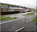
1
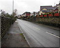
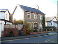
St Luke's Road walls, Pontnewynydd
The houses on the right are set above road level.
The wall on the left is above a path using the route of a dismantled railway.
Image: © Jaggery
Taken: 17 Dec 2015
0.03 miles
2
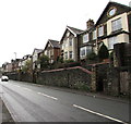
Groveside Villas, Pontnewynydd
Houses above the A4043 St Lukes Road.
Image: © Jaggery
Taken: 17 Dec 2015
0.03 miles
3
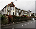
Southeast end of Groveside Villas, Pontnewynydd
Houses above the A4043 St Lukes Road.
Image: © Jaggery
Taken: 17 Dec 2015
0.05 miles
4
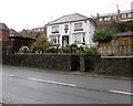
White house above St Luke's Road, Pontnewynydd
In an area of houses set above road level on this side of the A4043.
Image: © Jaggery
Taken: 17 Dec 2015
0.05 miles
5
Towards Machine Meadow houses, Pontnewynydd
From the edge of the A4043 St Luke's Road.
Image: © Jaggery
Taken: 17 Dec 2015
0.05 miles
6
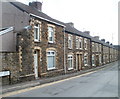
Torfaen Terrace, Pontnewynydd
On Freeholdland Road immediately south of the Afon Lwyd river bridge, this long row of houses is named Torfaen Terrace. The houses are numbered separately from other Freeholdland Road houses.
Image: © Jaggery
Taken: 9 May 2011
0.06 miles
7
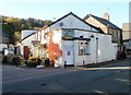
The Royal Oak, Pontnewynydd
Pub alongside the B4246. Some maps show this location as the southern end of Freeholdland Road whereas the pub's website states (the northern end of) George Street.
Image: © Jaggery
Taken: 25 Oct 2010
0.06 miles
8
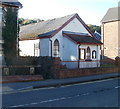
Emmaus Chapel, Pontnewynydd
Located on Freeholdland Road. The chapel is one of 35 chapels or churches in Wales which are affiliated to the Congregational Federation. On the left is Chapel House. http://www.geograph.org.uk/photo/2127916
Image: © Jaggery
Taken: 25 Oct 2010
0.06 miles
9
Chapel House, Pontnewynydd
Located on Freeholdland Road. Emmaus Chapel http://www.geograph.org.uk/photo/2127907 is on the right.
Image: © Jaggery
Taken: 25 Oct 2010
0.06 miles
10
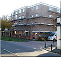
Belle Vue Court, Pontnewynydd
Located on George Street. One of several flats buildings in the area that were encased in scaffolding at the end of October 2010. On the right is the edge of The Royal Oak pub. http://www.geograph.org.uk/photo/2127888
Image: © Jaggery
Taken: 25 Oct 2010
0.06 miles