IMAGES TAKEN NEAR TO
Pentrepiod, Pontnewynydd, PONTYPOOL, NP4 6RR
Introduction
This page details the photographs taken nearby to NP4 6RR by members of the Geograph project.
The Geograph project started in 2005 with the aim of publishing, organising and preserving representative images for every square kilometre of Great Britain, Ireland and the Isle of Man.

There are currently over 7.5m images from over14,400 individuals and you can help contribute to the project by visiting https://www.geograph.org.uk
Image Map
Images are licensed for reuse under creativecommons.org/licenses/by-sa/2.0
Notes
- Clicking on the map will re-center to the selected point.
- The higher the marker number, the further away the image location is from the centre of the postcode.
Image Listing (72 Images Found)
Images are licensed for reuse under creativecommons.org/licenses/by-sa/2.0
Image
Details
Distance
1
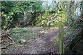
Path from western end of subway, Charlesville
The path from the subway Image goes up to the right to join the cycle route. The doorway, left, in the stone wall and the curved wall suggests that there was parkland/large garden on the far side of the wall which continues north.
Image: © M J Roscoe
Taken: 25 Feb 2022
0.04 miles
3
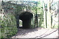
Subway under cycle route, Charlesville
Path from end of narrow lane goes under NCR 492 on former GWR railway. The path turns right Image at the far end of the subway.
Image: © M J Roscoe
Taken: 25 Feb 2022
0.04 miles
4
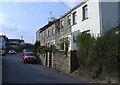
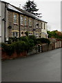
Slate Houses, Pentrepiod Road, Pontnewynydd
Row of three houses with slate roofs. The bilingual name sign
near the car shows that Slate Houses is Tai Llechi in Welsh.
Image: © Jaggery
Taken: 6 Nov 2018
0.06 miles
5
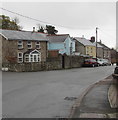
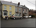
Housing variety, Pentrepiod Road, Pentrepiod, Torfaen
On the east side of the road.
Image: © Jaggery
Taken: 6 Nov 2018
0.06 miles
6
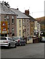
Two warning signs, Pentrepiod Road, Pontnewynydd
Bend to the left ahead and no footway for 200 yards. The houses are in Prospect Place.
Image: © Jaggery
Taken: 6 Nov 2018
0.07 miles
7
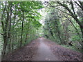
Woodland tunnel on NCN Route 46 near Pentre-Piod
Image: © Gareth James
Taken: 15 Oct 2011
0.07 miles
8
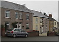
Prospect Place, Pentrepiod Road, Pontnewynydd
Separately named and numbered houses on the east side of Pentrepiod Road.
Image: © Jaggery
Taken: 6 Nov 2018
0.08 miles
9
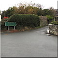
Ty Ceirios Nursing Home & Day Care direction sign, Pontnewynydd
The dark green sign alongside Pentrepiod Road shows the way to Ty Ceirios.
Image: © Jaggery
Taken: 6 Nov 2018
0.08 miles
10
Satellite dishes on stone houses, Pentrepiod Road, Pontnewynydd
Image: © Jaggery
Taken: 6 Nov 2018
0.08 miles