IMAGES TAKEN NEAR TO
Hanbury Road, PONTYPOOL, NP4 6PD
Introduction
This page details the photographs taken nearby to Hanbury Road, NP4 6PD by members of the Geograph project.
The Geograph project started in 2005 with the aim of publishing, organising and preserving representative images for every square kilometre of Great Britain, Ireland and the Isle of Man.

There are currently over 7.5m images from over14,400 individuals and you can help contribute to the project by visiting https://www.geograph.org.uk
Image Map
Images are licensed for reuse under creativecommons.org/licenses/by-sa/2.0
Notes
- Clicking on the map will re-center to the selected point.
- The higher the marker number, the further away the image location is from the centre of the postcode.
Image Listing (230 Images Found)
Images are licensed for reuse under creativecommons.org/licenses/by-sa/2.0
Image
Details
Distance
1
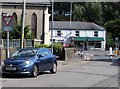
ILDIWCH/GIVE WAY 50 yards/50 llath, Hanbury Road, Pontnewynydd
The bilingual sign on the left is Welsh/English on the top and English/Welsh below.
Image: © Jaggery
Taken: 1 Sep 2016
0.01 miles
2
E.I.Peake Funeral Home, Hanbury Road, Pontnewynydd
Funeral directors at 87 Hanbury Road, near the corner of the A4043 Osborne Road (ahead).
Image: © Jaggery
Taken: 1 Sep 2016
0.02 miles
3
Unsuitable for HGVs sign at the eastern end of Hanbury Road, Pontnewynydd
Facing the A4043 Osborne Road. The arrows on the signs point this way. http://www.geograph.org.uk/photo/5101688
Image: © Jaggery
Taken: 1 Sep 2016
0.02 miles
4
Merchants Hill Baptist Church, Pontnewynydd
Located on the corner of Osborne Road and Merchants Hill. The inscription above the doorway is BAPTIST CHAPEL 1888.
Image: © Gerald England
Taken: Unknown
0.02 miles
5
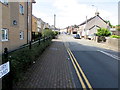
Up Hanbury Road, Pontnewynydd
Hanbury Road ascends from the corner of the A4043 Osborne Road.
Image: © Jaggery
Taken: 1 Sep 2016
0.02 miles
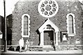
6
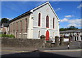
Pontnewynydd Methodist Church
This is the Hanbury Road side of the church on the corner of Pentrepiod Road.
The church is part of the Gwent Hills and Vales Methodist Circuit.
The inscription on the roundel above the central window is WESLEYAN CHAPEL 1849.
http://www.geograph.org.uk/photo/2127741 to an earlier view.
Image: © Jaggery
Taken: 1 Sep 2016
0.02 miles
7
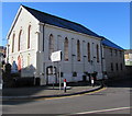
North side of Pontnewynydd Methodist Church
The Pentrepiod Road side of the church which is part of the Gwent
Hills and Vales Methodist Circuit. The building dates from 1849.
Image: © Jaggery
Taken: 2 Nov 2018
0.02 miles
8
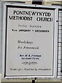
Information board, Pontnewynydd Methodist Church
Located here. http://www.geograph.org.uk/photo/5101652 In September 2016, Sunday Service is at 4pm.
Weekdays as announced. Weddings and baptisms by arrangement.
Image: © Jaggery
Taken: 1 Sep 2016
0.02 miles
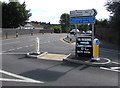
9
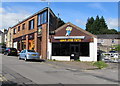
Quick Stop Party shop in Pontnewynydd
Balloon decorators and party ware shop viewed across Hanbury Road.
Image: © Jaggery
Taken: 1 Sep 2016
0.03 miles
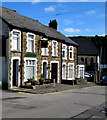
10
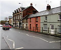
Houses, shops and railings, St Luke's Road, Pontnewynydd
Viewed across the A4043 St Luke's Road. The cars are near the Pentrepiod Road junction.
Image: © Jaggery
Taken: 17 Dec 2015
0.03 miles