IMAGES TAKEN NEAR TO
Forge Lane, PONTYPOOL, NP4 6JG
Introduction
This page details the photographs taken nearby to Forge Lane, NP4 6JG by members of the Geograph project.
The Geograph project started in 2005 with the aim of publishing, organising and preserving representative images for every square kilometre of Great Britain, Ireland and the Isle of Man.

There are currently over 7.5m images from over14,400 individuals and you can help contribute to the project by visiting https://www.geograph.org.uk
Image Map
Images are licensed for reuse under creativecommons.org/licenses/by-sa/2.0
Notes
- Clicking on the map will re-center to the selected point.
- The higher the marker number, the further away the image location is from the centre of the postcode.
Image Listing (503 Images Found)
Images are licensed for reuse under creativecommons.org/licenses/by-sa/2.0
Image
Details
Distance
1
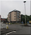
Ty Llwyd flats, Pontypool
21st century block of flats on the corner of Forge Lane and Riverside viewed in June 2017.
The flats are on a bank of a river (Afon Lwyd).
A September 2008 Google Earth Street View shows a fenced-off vacant site here.
Image: © Jaggery
Taken: 28 Jun 2017
0.01 miles
2
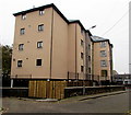
Ty Llwyd flats, Pontypool
21st century block of flats viewed across Forge Lane in November 2015.
The flats are on a bank of a river (Afon Lwyd).
A September 2008 Google Earth Street View shows a fenced-off vacant site here.
Image: © Jaggery
Taken: 3 Nov 2015
0.01 miles
3
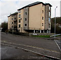
21st century Ty Llwyd flats, Pontypool
Block of flats on the corner of Forge Lane and Riverside viewed in March 2018. The flats are on a bank of a river (Afon Lwyd). A September 2008 Google Earth Street View shows a fenced-off vacant site here.
Image: © Jaggery
Taken: 15 Mar 2018
0.01 miles
4
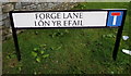
Bilingual name sign Forge Lane/L?n yr Efail, Pontypool
The English/Welsh sign is on the right here. https://www.geograph.org.uk/photo/5707918
Image: © Jaggery
Taken: 15 Mar 2018
0.01 miles
5
Southern end of Riverside, Pontypool
Viewed from the corner of Forge Lane. Riverside, along a bank of the Afon Lwyd,
leads to the A4043 600 metres away. The A4043 is a route to Blaenavon.
Image: © Jaggery
Taken: 3 Nov 2015
0.02 miles
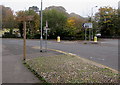
6
Wooden Community Link signpost in central Pontypool
On the corner of Riverside and Forge Lane.
Most of the locations and distances shown are for cycling and walking
routes using National Cycle Network Route 492, such as
12.9km to Blaenavon and 7.5km to Cwmbran.
Distances in miles are not shown.
Image: © Jaggery
Taken: 3 Nov 2015
0.02 miles
7
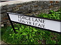
Forge Lane/L?n Yr Efail name sign, Pontypool
English and Welsh sign located on the right here. http://www.geograph.org.uk/photo/4731187
Image: © Jaggery
Taken: 3 Nov 2015
0.02 miles
8
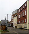
Forge Lane towards Town Bridge roundabout, Pontypool
Forge Lane is a dead-end street on a bank of a river, the Afon Lwyd.
Image: © Jaggery
Taken: 3 Nov 2015
0.02 miles
9
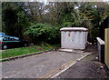
Pontypool Town electricity substation
Set back from the east side of Forge Lane, on a bank of a river, the Afon Lwyd.
The Western Power Distribution electricity substation identifier is PONTYPOOL TOWN S/S 53-6753.
Image: © Jaggery
Taken: 3 Nov 2015
0.02 miles
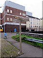
10
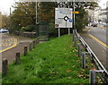
Town Bridge roundabout ahead, Pontypool
The sign is between Park Road on the left and Riverside on the right.
Image: © Jaggery
Taken: 3 Nov 2015
0.02 miles