IMAGES TAKEN NEAR TO
Fowler Street, PONTYPOOL, NP4 6DW
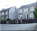
Introduction
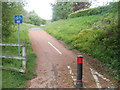
This page details the photographs taken nearby to Fowler Street, NP4 6DW by members of the Geograph project.
The Geograph project started in 2005 with the aim of publishing, organising and preserving representative images for every square kilometre of Great Britain, Ireland and the Isle of Man.

There are currently over 7.5m images from over14,400 individuals and you can help contribute to the project by visiting https://www.geograph.org.uk
Image Map
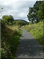
Images are licensed for reuse under creativecommons.org/licenses/by-sa/2.0
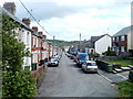
Notes
- Clicking on the map will re-center to the selected point.
- The higher the marker number, the further away the image location is from the centre of the postcode.
Image Listing (177 Images Found)
Images are licensed for reuse under creativecommons.org/licenses/by-sa/2.0
Image
Details
Distance
1

Ordnance Survey Cut Mark
This OS cut mark can be found on No55 Fowler Street. It marks a point 162.175m above mean sea level.
Image: © Adrian Dust
Taken: 7 Jul 2019
0.03 miles
2
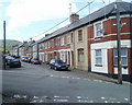
Fowler Street, Wainfelin, Pontypool
Houses on the north side of the street viewed from the western end of Wainfelin Road.
Image: © Jaggery
Taken: 10 May 2011
0.03 miles
3
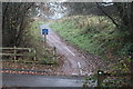
National Cycle Route 492, Elled Road, Pontnewynydd
Junction of cycle route, on former railway track bed, and Elled Road.
Image: © M J Roscoe
Taken: 6 Dec 2016
0.04 miles
4
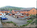
Corner of Merchant's Hill and Merchant's Hill Close, Pontnewynydd
Merchant's Hill houses near the corner of Merchant's Hill Close, at the right edge of the view.
Image: © Jaggery
Taken: 10 May 2011
0.04 miles
5
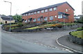
Merchant's Hill Close houses, Pontnewynydd
Modern housing occupying land adjacent to now-lifted railway lines, viewed from Merchant's Hill bridge.http://www.geograph.org.uk/photo/2425363
Pontnewynydd railway station (closed in 1962) was nearby.
Image: © Jaggery
Taken: 10 May 2011
0.04 miles
6
Cycle route 492, Wainfelin, Pontypool
National Cycle Network route 492 heads ENE away from Elled Road, about 50 metres south of The Little Crown Inn. http://www.geograph.org.uk/photo/2425452
Image: © Jaggery
Taken: 10 May 2011
0.04 miles
7
Cycle track on former railway line, Pontnewynydd
Image: © David Smith
Taken: 26 Sep 2021
0.05 miles
8
Wainfelin Road, Pontypool
Houses at the western end of Wainfelin Road viewed from top (SE) end of Merchant's Hill.
Image: © Jaggery
Taken: 10 May 2011
0.05 miles
9
Looking east along Fowler Street, Wainfelin, Pontypool
The view from an open space at the western end of the street, which runs due east for 175 metres to the junction of Merchant's Hill, Wainfelin Road and Penywain Road. Just out of shot beyond the lower left corner of the view, Fowler Street meets the southern end of Elled Road.
Image: © Jaggery
Taken: 10 May 2011
0.05 miles
10
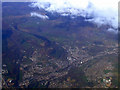
Pontypool from the air
Pontnewynydd is to the right in this view from a Bristol bound flight from Glasgow. The A472 road is to the left.
Image: © Thomas Nugent
Taken: 2 Apr 2012
0.05 miles