IMAGES TAKEN NEAR TO
Elled Road, PONTYPOOL, NP4 6DR
Introduction
This page details the photographs taken nearby to Elled Road, NP4 6DR by members of the Geograph project.
The Geograph project started in 2005 with the aim of publishing, organising and preserving representative images for every square kilometre of Great Britain, Ireland and the Isle of Man.

There are currently over 7.5m images from over14,400 individuals and you can help contribute to the project by visiting https://www.geograph.org.uk
Image Map
Images are licensed for reuse under creativecommons.org/licenses/by-sa/2.0
Notes
- Clicking on the map will re-center to the selected point.
- The higher the marker number, the further away the image location is from the centre of the postcode.
Image Listing (204 Images Found)
Images are licensed for reuse under creativecommons.org/licenses/by-sa/2.0
Image
Details
Distance
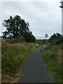
1
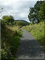
Cycle track on former railway line, Pontnewynydd
Image: © David Smith
Taken: 26 Sep 2021
0.02 miles
2
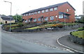
Corner of Merchant's Hill and Merchant's Hill Close, Pontnewynydd
Merchant's Hill houses near the corner of Merchant's Hill Close, at the right edge of the view.
Image: © Jaggery
Taken: 10 May 2011
0.03 miles
3
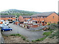
Merchant's Hill Close houses, Pontnewynydd
Modern housing occupying land adjacent to now-lifted railway lines, viewed from Merchant's Hill bridge.http://www.geograph.org.uk/photo/2425363
Pontnewynydd railway station (closed in 1962) was nearby.
Image: © Jaggery
Taken: 10 May 2011
0.03 miles
4
Cycle route 492, Wainfelin, Pontypool
National Cycle Network route 492 heads ENE away from Elled Road, about 50 metres south of The Little Crown Inn. http://www.geograph.org.uk/photo/2425452
Image: © Jaggery
Taken: 10 May 2011
0.03 miles
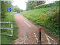
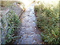
5
NCN492 south of Pontnewynydd
The cycle route follows the old railway through a shallow cutting
Image: © David Smith
Taken: 26 Sep 2021
0.03 miles
6
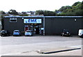
Pontypool Motor Factors in Pontnewynydd
Located in North Pontypool Industrial Park. Motor factors sell car parts and accessories.
Image: © Jaggery
Taken: 1 Sep 2016
0.04 miles
7
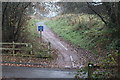
National Cycle Route 492, Elled Road, Pontnewynydd
Junction of cycle route, on former railway track bed, and Elled Road.
Image: © M J Roscoe
Taken: 6 Dec 2016
0.04 miles
8
A small stream (Nant Ffrwd-oer), Pontnewynydd
The stream has just emerged from flowing under Osborne Road (A4043) and now heads towards its end at the Afon Lwyd, a river less than 200 metres away. http://www.geograph.org.uk/photo/2422899 for a wider view.
Image: © Jaggery
Taken: 25 Oct 2010
0.04 miles
9
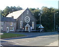
Merchants Hill Baptist Church, Pontnewynydd
Located on the corner of Osborne Road and Merchants Hill. The inscription above the doorway is BAPTIST CHAPEL 1888.
Image: © Jaggery
Taken: 25 Oct 2010
0.04 miles
10
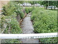
Nant Ffrwd-oer, Pontnewynydd, Pontypool
A stream emerges from its passage under Osborne Road (A4043) and flows towards its confluence with the Afon Lwyd, about 200 metres away.
Image: © Jaggery
Taken: 10 May 2011
0.04 miles