IMAGES TAKEN NEAR TO
Glengariff Court, PONTYPOOL, NP4 5LY
Introduction
This page details the photographs taken nearby to Glengariff Court, NP4 5LY by members of the Geograph project.
The Geograph project started in 2005 with the aim of publishing, organising and preserving representative images for every square kilometre of Great Britain, Ireland and the Isle of Man.

There are currently over 7.5m images from over14,400 individuals and you can help contribute to the project by visiting https://www.geograph.org.uk
Image Map
Images are licensed for reuse under creativecommons.org/licenses/by-sa/2.0
Notes
- Clicking on the map will re-center to the selected point.
- The higher the marker number, the further away the image location is from the centre of the postcode.
Image Listing (118 Images Found)
Images are licensed for reuse under creativecommons.org/licenses/by-sa/2.0
Image
Details
Distance
1
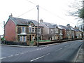
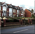
Greenhill Road houses, Griffithstown, Pontypool
Houses at the northern end of Greenhill Road, on the corner of Kemys Street. Just out of shot on the opposite corner (of Kemys Street and Sunnybank Road) is St Hilda's church. http://www.geograph.org.uk/photo/1577404
Image: © Jaggery
Taken: 21 Jan 2011
0.01 miles
2
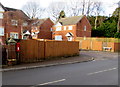
Greenhill Road postbox, Griffithstown, Pontypool
The Glengariff Court junction http://www.geograph.org.uk/photo/1577335 is on the right.
Image: © Jaggery
Taken: 24 Jan 2015
0.03 miles
3
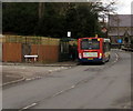
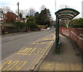
X24 bus in Griffithstown, Pontypool
On the X24 route from Newport to Blaenavon, the Stagecoach bus
is at the bus stop on the corner of Greenhill Road and Glengariff Court.
Image: © Jaggery
Taken: 27 Jan 2015
0.04 miles
4
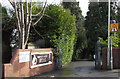
Entrance to Panteg House sports & social club, Griffithstown, Pontypool
From Greenhill Road.
Image: © Jaggery
Taken: 24 Jan 2015
0.05 miles
5
Greenhill Road houses, Griffithstown, Pontypool
On the west side of Greenhill Road, between The Avenue to the south and Glengariff Court to the north.
Image: © Jaggery
Taken: 24 Jan 2015
0.05 miles
6
Queensbury bus shelter, Greenhill Road, Pontypool
I expected to see a timetable on this shelter. There wasn't one. Instead there was a Queensbury Shelters Ltd notice which quotes good things said about the company by Mendip District Council, Peel Advertising, Swale Borough Council, Hampshire County Council and the Stratton Association of Parish Councils.
All very interesting, but I'd rather have seen a bus timetable here...
Image: © Jaggery
Taken: 27 Jan 2015
0.06 miles
7
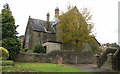
St Hilda's Church , Griffithstown, Pontypool
The view of the church from the southeast, on Kemys Street. St Hilda's Church is the Church in Wales (Anglican) parish church of Griffithstown. Built in 1887, it is a stone edifice in the Early English style, consisting of chancel, nave, aisles and south porch. http://www.geograph.org.uk/photo/1577404 to view from the southwest.
Image: © Jaggery
Taken: 21 Oct 2009
0.06 miles
8
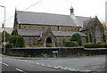
St Hilda's Church , Griffithstown, Pontypool
The view from the southwest. The church is on the corner of Sunnybank Road and Kemys Street. http://www.geograph.org.uk/photo/1577394 for the view from the southeast.
Image: © Jaggery
Taken: 21 Oct 2009
0.06 miles
9
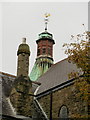
St Hilda's Church rooftop , Griffithstown, Pontypool
A closeup view of the church http://www.geograph.org.uk/photo/1577394 chimney and weather vane.
Image: © Jaggery
Taken: 21 Oct 2009
0.06 miles
10
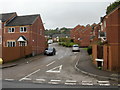
Glengariff Court, Griffithstown, Pontypool
Viewed from Greenhill Road.
Image: © Jaggery
Taken: 21 Oct 2009
0.06 miles