IMAGES TAKEN NEAR TO
Sunnybank Road, PONTYPOOL, NP4 5LT
Introduction
This page details the photographs taken nearby to Sunnybank Road, NP4 5LT by members of the Geograph project.
The Geograph project started in 2005 with the aim of publishing, organising and preserving representative images for every square kilometre of Great Britain, Ireland and the Isle of Man.

There are currently over 7.5m images from over14,400 individuals and you can help contribute to the project by visiting https://www.geograph.org.uk
Image Map
Images are licensed for reuse under creativecommons.org/licenses/by-sa/2.0
Notes
- Clicking on the map will re-center to the selected point.
- The higher the marker number, the further away the image location is from the centre of the postcode.
Image Listing (115 Images Found)
Images are licensed for reuse under creativecommons.org/licenses/by-sa/2.0
Image
Details
Distance
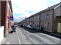
1
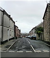
Edward Street, Griffithstown. Pontypool
The view along Edward Street looking towards Charles Street.
Image: © Jaggery
Taken: 21 Oct 2009
0.01 miles
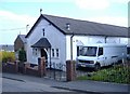
2
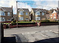
Detached houses, Sunnybank Road, Pontypool
Viewed from the corner of Edward Street. http://www.geograph.org.uk/photo/3416690
Image: © Jaggery
Taken: 18 Apr 2013
0.03 miles
3
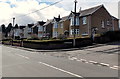
Sunnybank Road houses, Pontypool
The street name sign on the side road shows GREENWAY ESTATE.
Image: © Jaggery
Taken: 18 Apr 2013
0.04 miles
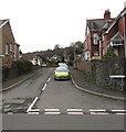
4
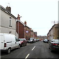
Edward Street, Griffithstown, Pontypool
Viewed from the Sunnybank Road end looking towards the distant Asquith Street junction.
Image: © Jaggery
Taken: 27 Jan 2015
0.04 miles
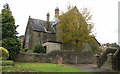
5
The Catholic Church of Our Most Holy Redeemer, Griffithstown
To be sold for residential development.
Image: © Roger Cornfoot
Taken: 11 Apr 2007
0.04 miles
6
Edward Street, Griffithstown, Pontypool
Viewed from the Sunnybank Road end.
Image: © Jaggery
Taken: 18 Apr 2013
0.05 miles
7
Greenway Estate, Griffithstown, Pontypool
Viewed across Sunnybank Road. The name sign on the right shows GREENWAY ESTATE.
The road leads to Sunnybank Way.
Image: © Jaggery
Taken: 27 Jan 2015
0.06 miles
8
St Hilda's Church , Griffithstown, Pontypool
The view of the church from the southeast, on Kemys Street. St Hilda's Church is the Church in Wales (Anglican) parish church of Griffithstown. Built in 1887, it is a stone edifice in the Early English style, consisting of chancel, nave, aisles and south porch. http://www.geograph.org.uk/photo/1577404 to view from the southwest.
Image: © Jaggery
Taken: 21 Oct 2009
0.07 miles
9
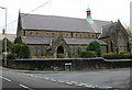
St Hilda's Church , Griffithstown, Pontypool
The view from the southwest. The church is on the corner of Sunnybank Road and Kemys Street. http://www.geograph.org.uk/photo/1577394 for the view from the southeast.
Image: © Jaggery
Taken: 21 Oct 2009
0.07 miles
10
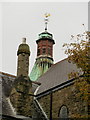
St Hilda's Church rooftop , Griffithstown, Pontypool
A closeup view of the church http://www.geograph.org.uk/photo/1577394 chimney and weather vane.
Image: © Jaggery
Taken: 21 Oct 2009
0.07 miles