IMAGES TAKEN NEAR TO
Penygraig Terrace, PONTYPOOL, NP4 5JS
Introduction
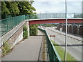
This page details the photographs taken nearby to Penygraig Terrace, NP4 5JS by members of the Geograph project.
The Geograph project started in 2005 with the aim of publishing, organising and preserving representative images for every square kilometre of Great Britain, Ireland and the Isle of Man.

There are currently over 7.5m images from over14,400 individuals and you can help contribute to the project by visiting https://www.geograph.org.uk
Image Map
Images are licensed for reuse under creativecommons.org/licenses/by-sa/2.0
Notes
- Clicking on the map will re-center to the selected point.
- The higher the marker number, the further away the image location is from the centre of the postcode.
Image Listing (244 Images Found)
Images are licensed for reuse under creativecommons.org/licenses/by-sa/2.0
Image
Details
Distance
1
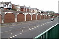
Bricked-up arches alongside A472, Pontymoel, Pontypool
The A472 here follows the course of a dismantled railway line. A long row of bricked-up arches line the southern side of the road. This view is towards houses on Park View Terrace, Pontymoel, also spelt Pontymoile.
Image: © Jaggery
Taken: 26 Jan 2011
0.01 miles
2
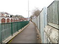
Footpath alongside A472, Pontypool
The footpath runs from Rockhill Road to Clarence Place. On the far side of the A472 is a long row of bricked-up arches. http://www.geograph.org.uk/photo/2250682
Image: © Jaggery
Taken: 26 Jan 2011
0.01 miles
3
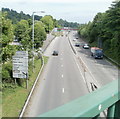
A472 heads east away from central Pontypool
The view from one footbridge towards another one about 200 metres away.
Image: © Jaggery
Taken: 16 May 2011
0.01 miles
4
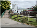
Steps to a footbridge over the A472, Pontypool
The footbridge connects Clarence Place, on the camera side of the A472, with Park View Terrace.
Image: © Jaggery
Taken: 9 Jun 2011
0.01 miles
5
Footpath alongside the A472 from Clarence Place to Rockhill Road, Pontypool
Heading towards Rockhill Road, the footpath passes under a footbridge http://www.geograph.org.uk/photo/2451682 over the A472.
Image: © Jaggery
Taken: 9 Jun 2011
0.01 miles
6
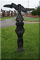
National Cycle Network marker post
Pontymoel, Pontypool.
Image: © Ian S
Taken: 26 May 2014
0.03 miles
7
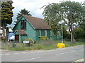
St Matthew's Church, Pontypool
There was a time, decades ago, when prefabricated corrugated-metal churches ("tin churches") were a common sight in many parts of the UK. Many have now been replaced by more modern buildings, but in Pontypool, two remain in use within about a kilometre of each other.
This one, on Victoria Road, is St Matthew's Church, Pontymoile, a Church in Wales church, diocese of Monmouth.
The other one is Race Methodist Church http://www.geograph.org.uk/photo/2452335 in Upper Race.
Image: © Jaggery
Taken: 9 Jun 2011
0.06 miles
8
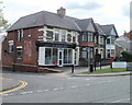
Former post office, Blaendare Road, Pontypool
A postbox is sometimes an indicator that the adjacent premises were formerly a post office. Such is the case here, on the corner of Blaendare Road and St Matthew's Road, Pontypool. Now The Batchelor Barber, this was Penygraig Terrace post office until closure in 2008.
Image: © Jaggery
Taken: 9 Jun 2011
0.06 miles
9
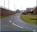
Junction of Clarence Road and Clarence Place, Pontypool
From Clarence Road, Clarence Place ascends towards the A472.
In 2020, Clarence Place is not a through route for motor vehicles.
Image: © Jaggery
Taken: 26 Jul 2020
0.06 miles
10
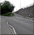
Slip road from A472, Pontymoel
The slip road from the A472 http://www.geograph.org.uk/photo/2250682 exits into Rockhill Road. On the right is the edge of Pontymoile Undenominational Christian Mission. http://www.geograph.org.uk/photo/2250514
Image: © Jaggery
Taken: 26 Jan 2011
0.06 miles