IMAGES TAKEN NEAR TO
St. Anthonys Close, PONTYPOOL, NP4 5EY
Introduction
This page details the photographs taken nearby to St. Anthonys Close, NP4 5EY by members of the Geograph project.
The Geograph project started in 2005 with the aim of publishing, organising and preserving representative images for every square kilometre of Great Britain, Ireland and the Isle of Man.

There are currently over 7.5m images from over14,400 individuals and you can help contribute to the project by visiting https://www.geograph.org.uk
Image Map
Images are licensed for reuse under creativecommons.org/licenses/by-sa/2.0
Notes
- Clicking on the map will re-center to the selected point.
- The higher the marker number, the further away the image location is from the centre of the postcode.
Image Listing (44 Images Found)
Images are licensed for reuse under creativecommons.org/licenses/by-sa/2.0
Image
Details
Distance
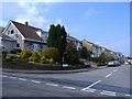
1
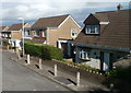
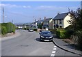
Southern end of St Anthony's Close, Griffithstown, Pontypool
Viewed from the Cwrdy Road end, from where there is no vehicular access to St Anthony's Close. Vehicles enter the close from St Augustine Road at its northern end.
Image: © Jaggery
Taken: 8 Oct 2011
0.03 miles
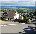
3
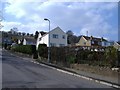
SE corner of St Augustine Road, Griffithstown, Pontypool
Viewed from the corner of Cwrdy Road. The course of St Augustine Road is roughly three sides of a rectangle. These houses are at the southern end of the eastern side of the rectangle.
Image: © Jaggery
Taken: 8 Oct 2011
0.04 miles
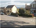
4
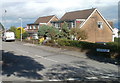
Houses at the western edge Griffithstown, Pontypool
Viewed from the corner of Cwrdy Road and Cwrdy Lane. http://www.geograph.org.uk/photo/3240014
These houses are in the western arm of St Augustine Road. Ahead, the road bends
to the right and rejoins Cwrdy Road about 100 metres to the east.
Image: © Jaggery
Taken: 8 Oct 2011
0.05 miles
6
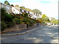
Steep descent, Cwrdy Road, Griffithstown, Pontypool
The steep descent of Cwrdy Lane http://www.geograph.org.uk/photo/3240014 from Penyrheol behind the camera continues ahead along Cwrdy Road.
Image: © Jaggery
Taken: 8 Oct 2011
0.06 miles
7
Flatter section of Cwrdy Road, Griffithstown, Pontypool
After a steep descent http://www.geograph.org.uk/photo/3240020 from Cwrdy Lane, Cwrdy Road traverses flattish land ahead.
The Spring Terrace junction is on the right.
Image: © Jaggery
Taken: 8 Oct 2011
0.07 miles
8
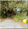
Eastern end of Cwrdy Lane, Griffithstown, Pontypool
Residential Cwrdy Road behind the camera narrows to Cwrdy Lane. Ahead is a steep climb to Penyrheol.
Image: © Jaggery
Taken: 8 Oct 2011
0.08 miles
10
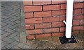
Ordnance Survey Cut Mark
This OS cut mark can be found on No28 Cwrdy Road. It marks a point 157.466m above mean sea level.
Image: © Adrian Dust
Taken: 16 Feb 2021
0.09 miles