1
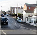
Kemys Street, Griffithstown, Pontypool
Viewed from near canal bridge 49, http://www.geograph.org.uk/photo/2246986 Kemys Street climbs towards Sunnybank Road and Greenhill Road, past turnings for Canal Close (pictured left) and Commercial Street (pictured right).
Image: © Jaggery
Taken: 21 Jan 2011
0.02 miles
2
Contrasts in terraced housing, Griffithstown
The lower [modern] houses are at the south end of Commercial Street, the higher, older ones in East View.
Image: © Christine Johnstone
Taken: 15 Sep 2013
0.05 miles
3
Ordnance Survey Cut Mark
This OS cut mark can be found on the SW angle of the Congregational Chapel, Kemys Street. It marks a point 128.601m above mean sea level.
Image: © Adrian Dust
Taken: 16 Feb 2021
0.05 miles
4
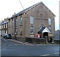
Congregational Church, Griffithstown, Pontypool
Located on the corner of Oxford Street and Kemys Street, viewed from Florence Place. The year inscribed in stone above the entrance is 1885.
Image: © Jaggery
Taken: 21 Jan 2011
0.05 miles
5
Oxford Street, Griffithstown, Pontypool
The southern end of Oxford Street, viewed across Kemys Street.
Image: © Jaggery
Taken: 24 Jan 2015
0.05 miles
6
North along Canal Close, Griffithstown, Pontypool
Looking towards Kemys Street from the southern end of Canal Close.
The canal in question is the former Monmouthshire & Brecon, a few metres to the east (right).
Image: © Jaggery
Taken: 24 Jan 2015
0.05 miles
7
Kemys Street, Griffithstown, Pontypool
Kemys Street climbs away from the Commercial Street junction. Hairs & Graces salon http://www.geograph.org.uk/photo/4323727 is on the right.
Image: © Jaggery
Taken: 24 Jan 2015
0.05 miles
8
Martindale Road, Griffithstown
Viewed from Station Road.
Image: © Jaggery
Taken: 21 Oct 2009
0.05 miles
9
Army Cadet Force (ACF), Griffithstown, Pontypool
Located within a fenced-off area on Canal Close, this is the building, officially termed a hut, of the Griffithstown Detachment of the ACF.
The role of the ACF is to inspire young people to achieve success with a spirit of service to the Queen, country and their local community, and to develop the qualities of good citizenship, responsibility and leadership.
Image: © Jaggery
Taken: 21 Jan 2011
0.05 miles
10
Disused canal south of bridge 49, Griffithstown, Pontypool
The view south, from bridge 49, http://www.geograph.org.uk/photo/2246986 along the former Monmouthshire & Brecon Canal.
Image: © Jaggery
Taken: 21 Jan 2011
0.05 miles


