IMAGES TAKEN NEAR TO
Grove Place, PONTYPOOL, NP4 5DH
Introduction
This page details the photographs taken nearby to Grove Place, NP4 5DH by members of the Geograph project.
The Geograph project started in 2005 with the aim of publishing, organising and preserving representative images for every square kilometre of Great Britain, Ireland and the Isle of Man.

There are currently over 7.5m images from over14,400 individuals and you can help contribute to the project by visiting https://www.geograph.org.uk
Image Map
Images are licensed for reuse under creativecommons.org/licenses/by-sa/2.0
Notes
- Clicking on the map will re-center to the selected point.
- The higher the marker number, the further away the image location is from the centre of the postcode.
Image Listing (144 Images Found)
Images are licensed for reuse under creativecommons.org/licenses/by-sa/2.0
Image
Details
Distance
1
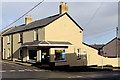
P.D.Powell & Sons in Griffithstown, Pontypool
Heating engineers shop on the corner of Kemys Street and Cambria Street.
Image: © Jaggery
Taken: 24 Jan 2015
0.04 miles
2
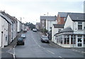
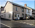
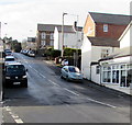
Kemys Street, Griffithstown, Pontypool
Viewed from near canal bridge 49, http://www.geograph.org.uk/photo/2246986 Kemys Street climbs towards Sunnybank Road and Greenhill Road, past turnings for Canal Close (pictured left) and Commercial Street (pictured right).
Image: © Jaggery
Taken: 21 Jan 2011
0.04 miles
3
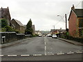
Kemys Street, Griffithstown, Pontypool
The view from Sunnybank Road. On the left is St Hilda's Church http://www.geograph.org.uk/photo/1577394 and its church hall. http://www.geograph.org.uk/photo/1577369
Image: © Jaggery
Taken: 21 Oct 2009
0.04 miles
4
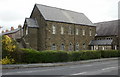
Congregational Church, Griffithstown, Pontypool
Located on the corner of Oxford Street and Kemys Street, viewed from Florence Place. The year inscribed in stone above the entrance is 1885.
Image: © Jaggery
Taken: 21 Jan 2011
0.05 miles
5
Oxford Street, Griffithstown, Pontypool
The southern end of Oxford Street, viewed across Kemys Street.
Image: © Jaggery
Taken: 24 Jan 2015
0.05 miles
6
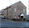
St Hilda's Church Hall, Griffithstown, Pontypool
Situated next to the church http://www.geograph.org.uk/photo/1577404 this stone building dates from the last decade of the 19th century. On the corner of Kemys Street and Cambria Street.
Image: © Jaggery
Taken: 21 Oct 2009
0.05 miles
7
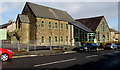
St Hilda's Church Hall, Griffithstown, Pontypool
Located on the north side of Kemys Street, to the east of St Hilda's Church. http://www.geograph.org.uk/photo/1577404
Built in 1927, refurbished in 2013, the hall is available for hire.
Image: © Jaggery
Taken: 24 Jan 2015
0.05 miles
8
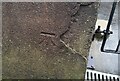
Ordnance Survey Cut Mark
This OS cut mark can be found on the SW angle of the Congregational Chapel, Kemys Street. It marks a point 128.601m above mean sea level.
Image: © Adrian Dust
Taken: 16 Feb 2021
0.05 miles
9
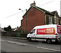
Iceland home delivery van, Kemys Street, Griffithstown, Pontypool
Viewed from the corner of Sunnybank Road in late January 2015 when Iceland shoppers
(in-store or via the Iceland website) can have free home delivery if they spend at least £25.
Image: © Jaggery
Taken: 27 Jan 2015
0.06 miles
10
Kemys Street, Griffithstown, Pontypool
Kemys Street climbs away from the Commercial Street junction. Hairs & Graces salon http://www.geograph.org.uk/photo/4323727 is on the right.
Image: © Jaggery
Taken: 24 Jan 2015
0.06 miles