IMAGES TAKEN NEAR TO
Caerleon Road, CWMBRAN, NP44 8TZ
Introduction
This page details the photographs taken nearby to Caerleon Road, NP44 8TZ by members of the Geograph project.
The Geograph project started in 2005 with the aim of publishing, organising and preserving representative images for every square kilometre of Great Britain, Ireland and the Isle of Man.

There are currently over 7.5m images from over14,400 individuals and you can help contribute to the project by visiting https://www.geograph.org.uk
Image Map
Images are licensed for reuse under creativecommons.org/licenses/by-sa/2.0
Notes
- Clicking on the map will re-center to the selected point.
- The higher the marker number, the further away the image location is from the centre of the postcode.
Image Listing (52 Images Found)
Images are licensed for reuse under creativecommons.org/licenses/by-sa/2.0
Image
Details
Distance
1
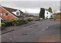
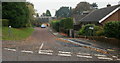
The end of the road, Edgehill, Cwmbran
The residential cul-de-sac Edgehill ends in front of the white house ahead.
The opposite end of Edgehill connects with the B4236. http://www.geograph.org.uk/photo/3280613
Image: © Jaggery
Taken: 3 Jan 2013
0.04 miles
2
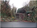
Steps up to Edgehill, Cwmbran
The steps give pedestrians a short cut between Crown Road
and the NW end of the residential cul-de-sac Edgehill. http://www.geograph.org.uk/photo/3280616
Image: © Jaggery
Taken: 3 Jan 2013
0.04 miles
3
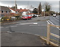
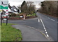
Corner of Crown Road and Caerleon Road, Cwmbran
Viewed from Caerleon Road (the B4236). The left turn into Crown Road gives a direct route to the Crown Roundabout between Llanyravon and Llantarnam.
Image: © Jaggery
Taken: 3 Jan 2013
0.05 miles
4
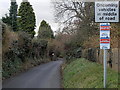
Oncoming vehicles in middle of road sign, Crown Road, Cwmbran
Beneath the larger road sign, a Trading Standards Notice states that this area is a Cold Calling Control Zone and shows a number to ring if you are cold called. Cold calling is the contacting by businesses or their agents of people thought to be potential customers, without the contact having been prearranged.
Image: © Jaggery
Taken: 3 Jan 2013
0.05 miles
5
High Close, Llanfrechfa
Viewed from Crown Rise
Image: © Jaggery
Taken: 15 Oct 2009
0.06 miles
6
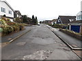
Edgehill, Cwmbran viewed from the far end
Viewed from the end of the road http://www.geograph.org.uk/photo/3280616 in the cul-de-sac Edgehill.
In the distance, the road bends to the left to connect with the B4236. http://www.geograph.org.uk/photo/3280613
Image: © Jaggery
Taken: 3 Jan 2013
0.06 miles
8
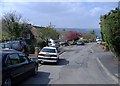
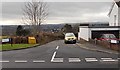
Crown Road, Llanfrechfa
Crown Road descends from Caerleon Road. The sign on the right warns of oncoming vehicles in the middle of the road.
Image: © Jaggery
Taken: 15 Oct 2009
0.07 miles
9
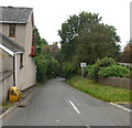
SE boundary of Cwmbran
The B4236 from Caerleon via Ponthir and Llanfrechfa reaches the Cwmbran
boundary sign located on the corner of the residential cul-de-sac Edgehill.
Image: © Jaggery
Taken: 3 Jan 2013
0.07 miles
10
NE end of Edgehill, Cwmbran
Viewed across the B4236. Edgehill is a residential cul-de-sac at the SE edge of Cwmbran.
Image: © Jaggery
Taken: 3 Jan 2013
0.08 miles