1
Police cordon vehicles, Cwmbran
The two metallic vehicles are in a car park near the Gwent Police Headquarters
in Croesyceiliog, Cwmbran.
Image: © Jaggery
Taken: 30 Aug 2013
0.02 miles
2
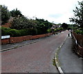
Up Llanyravon Way, Cwmbran
Llanyravon Way ascends towards the Croesyceiliog area of Cwmbran.
Llanyrafon Methodist Church http://www.geograph.org.uk/photo/5349208 is on the right.
In 2017, the Welsh Llanyrafon and the slightly Anglicised Llanyravon are
about equally common in English language use in this area of Cwmbran.
Image: © Jaggery
Taken: 12 Apr 2017
0.04 miles
3
Llanyrafon Methodist Church, Cwmbran
Viewed across Llanyravon (or Llanyrafon) Way. The name above the church entrance uses the Welsh spelling Llanyrafon as does a nearby street name sign. Two other signs lower down the road show the slightly Anglicised spelling Llanyravon.
Image: © Jaggery
Taken: 30 Aug 2013
0.05 miles
4
Southeast side of Llanyrafon Methodist Church, Cwmbran
This is the Liswerry Drive side of the church on the corner of Llanyravon Way.
http://www.geograph.org.uk/photo/5349208 to the front of the church which is in the Gwent Hills & Vales Circuit
of the Wales Synod, Methodist Church of Great Britain.
Llanyrafon in Welsh is also spelt Llanyravon in English. The two spellings appear
to be about equally common hereabouts in 2017. The church name uses Llanyrafon
whereas a nearby street name sign shows Llanyravon Way.
Image: © Jaggery
Taken: 12 Apr 2017
0.05 miles
5
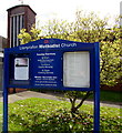
Llanyrafon Methodist Church information board, Cwmbran
Located here. http://www.geograph.org.uk/photo/5349208
Image: © Jaggery
Taken: 12 Apr 2017
0.05 miles
6
Llanyrafon Methodist Church, Cwmbran
This is the Llanyravon Way side of the church on the corner of Liswerry Drive.
The church is in the Gwent Hills & Vales Circuit of the Wales Synod, Methodist Church of Great Britain.
Llanyrafon in Welsh is also spelt Llanyravon in English. The two spellings appear
to be about equally common hereabouts in 2017. The church name uses Llanyrafon
whereas a nearby street name sign shows Llanyravon Way.
Image: © Jaggery
Taken: 12 Apr 2017
0.05 miles
7
Hole in the hedge entrance to The Pastures, Llanyrafon
Pedestrians have a short cut into The Pastures through this hole in the hedge on the north side of Llanyrafon Way. On the other side of the hedge, steps lead down into The Pastures.
Image: © Jaggery
Taken: 11 Feb 2010
0.05 miles
8
Llanyrafon Methodist Church
The modern Methodist church building on Llanyrafon Way.
Image: © David Roberts
Taken: 19 Feb 2009
0.05 miles
9
Gloucester Close, Cwmbran
Gloucester Close is a 110 metre long cul-de-sac on the south side of Llanyravon Way. Though the Welsh name for Gloucester is Caerloyw, the bilingual street name sign shows Caerloyn, probably the result of a misreading either in the street name department of the local council, or at the signmakers.
The confusion is understandable as the Welsh for nearby Caerleon is Caerllion.
Image: © Jaggery
Taken: 30 Aug 2013
0.06 miles
10
Llanyrafon Church Gates
The gates of Llanyrafon Methodist Church.
Image: © David Roberts
Taken: 19 Feb 2009
0.06 miles


