IMAGES TAKEN NEAR TO
Upper Cwmbran, CWMBRAN, NP44 5AG
Introduction
This page details the photographs taken nearby to NP44 5AG by members of the Geograph project.
The Geograph project started in 2005 with the aim of publishing, organising and preserving representative images for every square kilometre of Great Britain, Ireland and the Isle of Man.

There are currently over 7.5m images from over14,400 individuals and you can help contribute to the project by visiting https://www.geograph.org.uk
Image Map
Images are licensed for reuse under creativecommons.org/licenses/by-sa/2.0
Notes
- Clicking on the map will re-center to the selected point.
- The higher the marker number, the further away the image location is from the centre of the postcode.
Image Listing (47 Images Found)
Images are licensed for reuse under creativecommons.org/licenses/by-sa/2.0
Image
Details
Distance
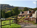
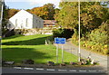
1
Upper Cwmbran Crossroads
Stones line a grassy patch at the crossroads at Upper Cwmbran. On the following day, Stagecoach will cease operating the bus service from Cwmbran town centre.
Image: © David Roberts
Taken: 20 Feb 2009
0.02 miles
2
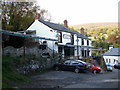
The Bush Inn, Upper Cwmbran
Little is known about the history of the Bush Inn. One possibility is that the pub originally consisted of two cottages which were linked to form the existing premises. The Bush Inn is shown on an 1860s OS map together with the now demolished Crown. There is an inn shown on an 1830s map, but it is unclear whether this was The Bush Inn or The Crown.
The Bush Inn , The Crown, The Squirrel (at the Square - now demolished) and The Queen http://www.geograph.org.uk/photo/1612705 were used by workers at the adjacent quarry, mine and brickyards, all now closed.
Image: © Jaggery
Taken: 17 Oct 2009
0.04 miles
3
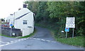
Junction of Graig Road and Tram Road, Upper Cwmbran
On the left, Tram Road heads towards Thornhill Road but only pedestrian access is possible at the end of the road, hence the No Through Road sign.
The sign on the right states that Graig Road is closed three-quarters of a mile ahead, but there is still access to the Bush Inn pub. http://www.geograph.org.uk/photo/1639126
Image: © Jaggery
Taken: 17 Oct 2009
0.04 miles
4
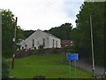
Siloam Baptist Chapel, Upper Cwmbran
According to tradition, meetings of Baptists in the Upper Cwmbran area were held in people's homes until the chapel was built in 1838. This date follows very closely on the opening of the Porthmawr Colliery- better known locally as the Clay level- and the expansion of the brickworks.
Image: © Eirian Evans
Taken: 31 May 2008
0.04 miles
5
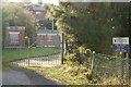
Entrance to Blaen Bran service reservoir, Upper Cwmbran
Image: © Jaggery
Taken: 17 Oct 2009
0.04 miles
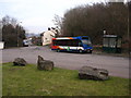
6
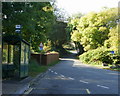
Bus terminus, Upper Cwmbran
The bus stop is the terminus of the route 8 service from Cwmbran bus station, operated by Terry Ward. The road ahead climbs towards The Square http://www.geograph.org.uk/photo/328454.
Image: © Jaggery
Taken: 17 Oct 2009
0.04 miles
7
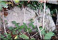
Ordnance Survey Cut Mark
This OS cut mark can be found on the wall north side of Upper Cwmbran Road. It marks a point 176.202m above mean sea level.
Image: © Adrian Dust
Taken: 17 Aug 2020
0.05 miles
8
Mountain Road, Upper Cwmbran
Mountain Road heads away north from the crossroads where Upper Cwmbran Road, Graig Road and Tram Road converge. The road is unsuitable for heavy goods vehicle, and it is steep enough to cause problems for some walkers.
On the left is Siloam Baptist Chapel. http://www.geograph.org.uk/photo/1638934
Image: © Jaggery
Taken: 17 Oct 2009
0.05 miles
9
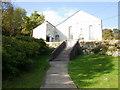
Siloam Baptist Chapel, Upper Cwmbran
The chapel was built in 1838. On the left is the vestry, built in 1904 and extended in 1988.
Image: © Jaggery
Taken: 17 Oct 2009
0.05 miles