IMAGES TAKEN NEAR TO
Cwrt Celyn, CWMBRAN, NP44 3FE
Introduction
This page details the photographs taken nearby to Cwrt Celyn, NP44 3FE by members of the Geograph project.
The Geograph project started in 2005 with the aim of publishing, organising and preserving representative images for every square kilometre of Great Britain, Ireland and the Isle of Man.

There are currently over 7.5m images from over14,400 individuals and you can help contribute to the project by visiting https://www.geograph.org.uk
Image Map
Images are licensed for reuse under creativecommons.org/licenses/by-sa/2.0
Notes
- Clicking on the map will re-center to the selected point.
- The higher the marker number, the further away the image location is from the centre of the postcode.
Image Listing (79 Images Found)
Images are licensed for reuse under creativecommons.org/licenses/by-sa/2.0
Image
Details
Distance
1
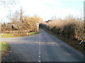
Cwmbran : St Dials Road narrows to a single-track road
Just beyond the entrance to a small parking area, beyond the left edge of the view, St Dials Road http://www.geograph.org.uk/photo/2290556 narrows to a single-track road.
Image: © Jaggery
Taken: 30 Jan 2011
0.02 miles
2
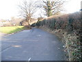
St Dials Road, Cwmbran
Though in the middle of Cwmbran, a town of about 50,000 inhabitants, St Dials Road looks much as it would have done in the first half of the 20th century. At that time it connected the village of St Dials with the village of Cwmbran. Following the rapid growth of Cwmbran after it was designated a New Town in 1949, St Dials is now a district of Cwmbran, and Cwmbran village is now known as Old Cwmbran.
Viewed from near the roundabout at the meeting of Ty Gwyn Way, Greenforge Way, Greenmeadow Way and St Dials Road. The street name sign shows
St Dials Road leading to Uplands Terrace http://www.geograph.org.uk/photo/2290627 and Hodges Terrace. http://www.geograph.org.uk/photo/2290976
A few metres ahead, the road narrows to single-track. http://www.geograph.org.uk/photo/2290579
Image: © Jaggery
Taken: 30 Jan 2011
0.02 miles
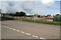
3
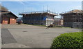
House construction site, Greenmeadow, Cwmbran
On the former Police Training College site, viewed in April 2017.
Greenmeadow Surgery http://www.geograph.org.uk/photo/5343689 is on the left.
Image: © Jaggery
Taken: 9 Apr 2017
0.04 miles
4
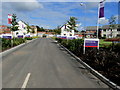
Cwrt Celyn, Parc Celyn, Cwmbran
Cwrt Celyn is a road from Greenmeadow Way into Parc Celyn, recently-built Taylor Wimpey houses
on part of the site previously occupied by a police training centre, viewed on October 10th 2016.
Image: © Jaggery
Taken: 10 Oct 2016
0.05 miles
5
Electricity substation at the edge of a construction site, Cwmbran
The dark green cabinet is a Western Power Distribution electricity substation alongside Greenmeadow Way at the edge of a house construction site on land previously occupied by a police training centre.
Image: © Jaggery
Taken: 10 Oct 2016
0.05 miles
6
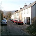
Uplands Terrace, St Dials Road, Cwmbran
A row of houses adjacent to St Dials allotments.
Image: © Jaggery
Taken: 30 Jan 2011
0.05 miles
7
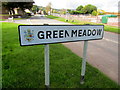
Greenmeadow boundary sign, Cwmbran
Facing Greenmeadow Way at the southeast edge of the Greenmeadow area of Cwmbran.
Image: © Jaggery
Taken: 10 Oct 2016
0.06 miles
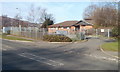
8
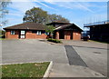
Greenmeadow Surgery, Cwmbran
Medical surgery set back from Greenmeadow Way in the Greenmeadow area of Cwmbran.
Image: © Jaggery
Taken: 9 Apr 2017
0.06 miles
9
Greenmeadow Surgery, Cwmbran
At the northern end of Greenmeadow Way, near the roundabout where Ty Gwyn Way, Greenforge Way, St Dials Road and Greenmeadow Way meet.
Image: © Jaggery
Taken: 30 Jan 2011
0.08 miles
10
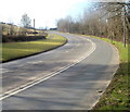
Steep climb ahead, Greenforge Way, Cwmbran
Though in the middle of Cwmbran, Greenforge Way has a rural appearance in this section. There are two lanes for ascending traffic, one lane for descending traffic.
Image: © Jaggery
Taken: 30 Jan 2011
0.08 miles