IMAGES TAKEN NEAR TO
Greenhill Road, CWMBRAN, NP44 3DQ
Introduction
This page details the photographs taken nearby to Greenhill Road, NP44 3DQ by members of the Geograph project.
The Geograph project started in 2005 with the aim of publishing, organising and preserving representative images for every square kilometre of Great Britain, Ireland and the Isle of Man.

There are currently over 7.5m images from over14,400 individuals and you can help contribute to the project by visiting https://www.geograph.org.uk
Image Map
Images are licensed for reuse under creativecommons.org/licenses/by-sa/2.0
Notes
- Clicking on the map will re-center to the selected point.
- The higher the marker number, the further away the image location is from the centre of the postcode.
Image Listing (266 Images Found)
Images are licensed for reuse under creativecommons.org/licenses/by-sa/2.0
Image
Details
Distance
1
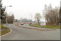
Short connecting road between two roundabouts, Cwmbran
An unnamed road, about 100 metres long, connects the Cwmbran Drive roundabout at Forge Hammer with the Maendy Way/Chapel Street roundabout ahead.
The sign on the right shows (distances in miles):
Upper Cwmbran 1
Springvale ½
Pontnewydd ¼
Town Centre ¼
Image: © Jaggery
Taken: 26 Mar 2011
0.01 miles
2
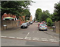
Northern arm of Greenhill Road, Cwmbran
The main part of Greenhill Road is aligned east-west from the Woodside Road junction.
The name signs alongside this northern arm show GREENHILL ROAD 4-21.
Image: © Jaggery
Taken: 23 Jul 2016
0.01 miles
3
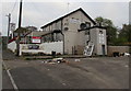
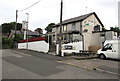
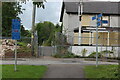
Greenhill Road pub to let, Cwmbran
On April 29th 2017 a Fleurets To Let board is on a derelict pub.
Dumped rubbish and window frames add to the derelict appearance.
Three different pub names are in view on the same premises -
The New Bridgend Inn, The Bottom Bridge and The Newbridgend Inn.
Image: © Jaggery
Taken: 29 Apr 2017
0.02 miles
4
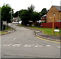
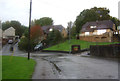
Junction of Woodside Road and Greenhill Road, Cwmbran
Greenhill Road ascends from the north side of Woodside Road.
The sign on the left points towards the RAFA club. http://www.geograph.org.uk/photo/5082132
Image: © Jaggery
Taken: 23 Jul 2016
0.02 miles
5
New Bridgend Inn, Cwmbran
Viewed across Greenhill Road in the Forgehammer area of Cwmbran.
The New Bridgend Inn is also known as the Bottom Bridge.
One name is on the post on the left, the other on the side wall on the right.
Image: © Jaggery
Taken: 23 Jul 2016
0.03 miles
6
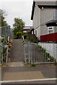
North along National Cycle Network route 49, Cwmbran
The cycleway and footpath heads north away from Greenhill Road.
For much of its 32km (20 miles) length from Newport to Abergavenny,
Route 49 is alongside or near the Monmouthshire & Brecon canal.
Image: © Jaggery
Taken: 29 Apr 2017
0.03 miles
8
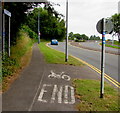
End of cycle route near Cwmbran Drive, Cwmbran
To the right of the END painted on the cycle route, the white arrow on a small blue sign points right to the continuation of National Cycle Network route 492.
Image: © Jaggery
Taken: 23 Jul 2016
0.03 miles
9
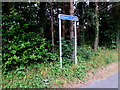
Cycle route distance sign, Cwmbran
Four and a half miles from Newport.
Image: © Jaggery
Taken: 23 Jul 2016
0.03 miles
10
Cycle route signs, Greenhill Road
Bilingual route direction signs at junction of NCR 492 with NCR 49 which follows the canal towpath straight ahead; the canal is culverted here. On the right is a disused public house.
Image: © M J Roscoe
Taken: 11 Sep 2021
0.03 miles