IMAGES TAKEN NEAR TO
Croesyceiliog, CWMBRAN, NP44 2AX
Introduction
This page details the photographs taken nearby to NP44 2AX by members of the Geograph project.
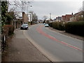
The Geograph project started in 2005 with the aim of publishing, organising and preserving representative images for every square kilometre of Great Britain, Ireland and the Isle of Man.

There are currently over 7.5m images from over14,400 individuals and you can help contribute to the project by visiting https://www.geograph.org.uk
Image Map
Images are licensed for reuse under creativecommons.org/licenses/by-sa/2.0
Notes
- Clicking on the map will re-center to the selected point.
- The higher the marker number, the further away the image location is from the centre of the postcode.
Image Listing (70 Images Found)
Images are licensed for reuse under creativecommons.org/licenses/by-sa/2.0
Image
Details
Distance
1
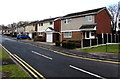
Plantation Drive houses in Croesyceiliog, Cwmbran
Viewed from Turnpike Road. The back gardens of these houses are at the edge of a wood named The Plantation.
Image: © Jaggery
Taken: 15 Feb 2015
0.13 miles
2
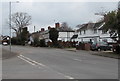
Houses alongside The Highway, Croesyceiliog, Cwmbran
Viewed from the corner of North Road.
Image: © Jaggery
Taken: 27 Feb 2018
0.13 miles
3
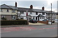
Row of houses alongside The Highway, Croesyceiliog, Cwmbran
South of the North Road junction.
Image: © Jaggery
Taken: 27 Feb 2018
0.14 miles
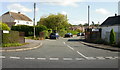
4
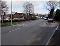
NE along The Highway, Croesyceiliog, Cwmbran
Viewed from opposite the North Road junction.
Image: © Jaggery
Taken: 15 Feb 2015
0.15 miles
5
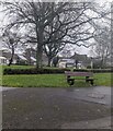
Bench on grass, Croesyceiliog, Cwmbran
On the corner of The Highway and North Road.
Image: © Jaggery
Taken: 24 Dec 2023
0.15 miles
6
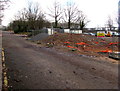
Mounds of rubble in the former County Hall site, Croesyceiliog, Cwmbran
Viewed through this http://www.geograph.org.uk/photo/4589015 gate in February 2015. The former County Hall http://www.geograph.org.uk/photo/2599278 was demolished in 2013 after being condemned because concrete cancer allowed rain to penetrate the cladding, rusting steel supports.
Image: © Jaggery
Taken: 15 Feb 2015
0.15 miles
7
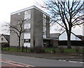
Bron-y-Garth, Croesyceiliog, Cwmbran
Small block of flats viewed across The Highway.
Image: © Jaggery
Taken: 15 Feb 2015
0.15 miles
8
Ashford Close, Croesyceiliog
Heading away from The Highway towards the junction with Ashford Close North and Ashford Close South. It appears on some maps that the far end of Ashford Close joins with The Plantation, but that is not so. The ends of the two roads are separated by trees.
Image: © Jaggery
Taken: 8 Oct 2009
0.15 miles
9
Up The Highway, Croesyceiliog, Cwmbran
The Highway ascends towards the North Road junction.
Image: © Jaggery
Taken: 27 Feb 2018
0.15 miles
10

Former entrance to County Hall, Cwmbran
This used to be the entrance to County Hall from the Turnpike Road roundabout.
In this early April 2013 view, the area is a now fenced-off demolition site where
little remains http://www.geograph.org.uk/photo/3632990 of the former multi-storey building which closed in March 2012.
In the background is the Gwent Police Headquarters building.
Image: © Jaggery
Taken: 7 Apr 2013
0.16 miles