IMAGES TAKEN NEAR TO
Upper Cwmbran, CWMBRAN, NP44 1AB
Introduction
This page details the photographs taken nearby to NP44 1AB by members of the Geograph project.
The Geograph project started in 2005 with the aim of publishing, organising and preserving representative images for every square kilometre of Great Britain, Ireland and the Isle of Man.

There are currently over 7.5m images from over14,400 individuals and you can help contribute to the project by visiting https://www.geograph.org.uk
Image Map
Images are licensed for reuse under creativecommons.org/licenses/by-sa/2.0
Notes
- Clicking on the map will re-center to the selected point.
- The higher the marker number, the further away the image location is from the centre of the postcode.
Image Listing (12 Images Found)
Images are licensed for reuse under creativecommons.org/licenses/by-sa/2.0
Image
Details
Distance
1
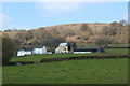
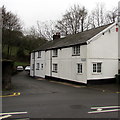
Bryn, Bevan's Lane
Mynydd Twyn-glas is on the skyline beyond the farm buildings.
Image: © M J Roscoe
Taken: 12 Apr 2019
0.18 miles
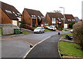
2
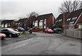
Houses at the northwest end of Five Locks Close, Cwmbran
Five Locks Close is on the north side of Five Locks Road.
Image: © Jaggery
Taken: 6 Mar 2019
0.21 miles
3
Canal Tunnel South Entrance
Southern Entrance to tunnel on Monmouthshire and Brecon canal (Map ref 287973)
Image: © gj
Taken: 14 May 2005
0.21 miles
4
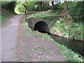
Canal Tunnel North Entrance
Northern Entrance to tunnel on Monmouthshire and Brecon canal (Map ref 287973)
Image: © gj
Taken: 14 May 2005
0.21 miles
5
This way to Pontnewydd Golf Club, Cwmbran
The sign on the house corner points along the side road to Pontnewydd Golf Club.
The side road junction is where Upper Cwmbran Road to the left becomes Ty Pwca Road to the right.
Image: © Jaggery
Taken: 29 Mar 2017
0.22 miles
6
Houses at the northeast end of Five Locks Close, Cwmbran
Five Locks Close is on the north side of Five Locks Road.
Image: © Jaggery
Taken: 6 Mar 2019
0.24 miles
7
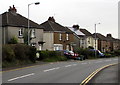
Ty Pwca Road semis, Cwmbran
Semi-detached houses on the north side of Ty Pwca Road.
Image: © Jaggery
Taken: 29 Mar 2017
0.24 miles
8
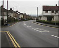
From Upper Cwmbran Road to Ty Pwca Road, Cwmbran
The junction on the left is where Upper Cwmbran Road on this side becomes Ty Pwca Road ahead.
The small brown sign on the right points towards the side road which leads to Pontnewydd Golf Club.
Image: © Jaggery
Taken: 29 Mar 2017
0.24 miles
9
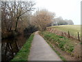
Approaching a canal tunnel, Cwmbran
Cwmbran Tunnel http://www.geograph.org.uk/photo/2572822 on the disused Monmouthshire & Brecon canal is around the bend ahead. The former towpath is now a footpath and cycle way.
Image: © Jaggery
Taken: 26 Mar 2011
0.24 miles
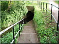
10
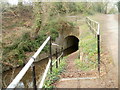
Steps down to Cwmbran canal tunnel
Steps descend to the SW portal of the tunnel, which conveys the disused Monmouthshire & Brecon canal for 87 yards (80m).
http://www.geograph.org.uk/photo/2572858 to the other end of the tunnel. The location is roughly midway between Cwmbran and Pontypool.
Image: © Jaggery
Taken: 26 Mar 2011
0.25 miles