IMAGES TAKEN NEAR TO
Church Lane, PONTYPOOL, NP4 0TS
Introduction
This page details the photographs taken nearby to Church Lane, NP4 0TS by members of the Geograph project.
The Geograph project started in 2005 with the aim of publishing, organising and preserving representative images for every square kilometre of Great Britain, Ireland and the Isle of Man.

There are currently over 7.5m images from over14,400 individuals and you can help contribute to the project by visiting https://www.geograph.org.uk
Image Map
Images are licensed for reuse under creativecommons.org/licenses/by-sa/2.0
Notes
- Clicking on the map will re-center to the selected point.
- The higher the marker number, the further away the image location is from the centre of the postcode.
Image Listing (120 Images Found)
Images are licensed for reuse under creativecommons.org/licenses/by-sa/2.0
Image
Details
Distance
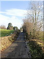
1
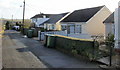
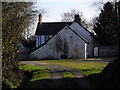
Church Lane - houses end here
This is roughly the midway point along Church Lane as it heads away from New Inn towards St Mary's Church.http://www.geograph.org.uk/photo/1667480
For most of the lane's length, there are fields on either side. The houses are all on the south side of the lane. Those seen here mark the end of the houses in the direction of the church.
Image: © Jaggery
Taken: 17 Jan 2010
0.05 miles
2
Dunnet Gardens, New Inn
Houses on the south side of Dunnet Gardens, close to the junction with Jerusalem Lane.
Image: © Jaggery
Taken: 17 Jan 2010
0.09 miles
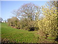
3
Hedges bordering Church Lane, Panteg
Hedges line the northern edge of Church Lane as it bends towards St Mary's Church
http://www.geograph.org.uk/photo/1667480 , visible in the distance.
Image: © Jaggery
Taken: 17 Jan 2010
0.09 miles
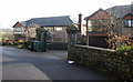
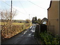
4
Entrance to Church Farm, Panteg
Viewed from Church Lane.
Image: © Jaggery
Taken: 17 Jan 2010
0.09 miles
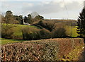
5
Church Lane, Panteg
Church Lane climbs away from the Church Farm entrance turnoff, towards St Mary's Church. http://www.geograph.org.uk/photo/1667480
Image: © Jaggery
Taken: 17 Jan 2010
0.09 miles
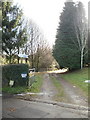
7
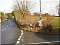
A holy junction, New Inn
The junction of Jerusalem Lane and Church Lane. On the pole, between the signs to St Mary's Church, is a notice stating that services are currently held in the church hall http://www.geograph.org.uk/photo/1667470 on The Highway.
Image: © Jaggery
Taken: 17 Jan 2010
0.11 miles
8
Church Lane
Church Lane heads away from New Inn towards St Mary's church, http://www.geograph.org.uk/photo/1667480 Panteg
Image: © Jaggery
Taken: 17 Jan 2010
0.11 miles
10
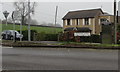
BT phonebox, Newport Road, New Inn
Near the Jerusalem Lane junction.
Image: © Jaggery
Taken: 12 Apr 2018
0.12 miles