IMAGES TAKEN NEAR TO
Clos Y Felin, PONTYPOOL, NP4 0BY
Introduction
This page details the photographs taken nearby to Clos Y Felin, NP4 0BY by members of the Geograph project.
The Geograph project started in 2005 with the aim of publishing, organising and preserving representative images for every square kilometre of Great Britain, Ireland and the Isle of Man.

There are currently over 7.5m images from over14,400 individuals and you can help contribute to the project by visiting https://www.geograph.org.uk
Image Map
Images are licensed for reuse under creativecommons.org/licenses/by-sa/2.0
Notes
- Clicking on the map will re-center to the selected point.
- The higher the marker number, the further away the image location is from the centre of the postcode.
Image Listing (72 Images Found)
Images are licensed for reuse under creativecommons.org/licenses/by-sa/2.0
Image
Details
Distance
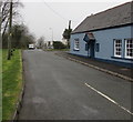
1
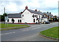
Lower New Inn pub, Lower New Inn, Pontypool
Located a few metres inside the SE boundary of New Inn, on the corner of Newport Road and Lancaster Road.
Image: © Jaggery
Taken: 23 Jun 2011
0.03 miles
2
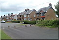
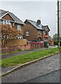
Houses at the SE edge of residential New Inn, Pontypool
These Newport Road houses are adjacent to the New Inn boundary. From here south to Cwmbran is mostly agricultural land, with a few houses here and there.
Image: © Jaggery
Taken: 23 Jun 2011
0.03 miles
3
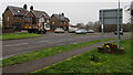
Southern boundary of New Inn, Pontypool
Newport Road reaches the edge of New Inn. The building on the left is the Lower New Inn http://www.geograph.org.uk/photo/2474109 which is also the name of this area of New Inn.
Image: © Jaggery
Taken: 23 Jun 2011
0.03 miles
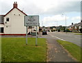
4
Welcome to New Inn - Please drive carefully
The sign is alongside Newport Road in the Lower New Inn area of New Inn. The text is also in Welsh.
The building is the Lower New Inn gastropub https://www.geograph.org.uk/photo/5735930 on the corner of Lancaster Road.
Image: © Jaggery
Taken: 12 Apr 2018
0.03 miles
5
West along Lancaster Road, Lower New Inn
From Newport Road past the southern edge of Lower New Inn gastropub. https://www.geograph.org.uk/photo/5735930
A sign behind the camera shows that Lancaster Road leads to Monmouth Close, Warwick Close, Church Close.
Image: © Jaggery
Taken: 12 Apr 2018
0.03 miles
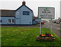
6
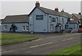
Lower New Inn in Lower New Inn
Lower New Inn gastropub in Newport Road, Lower New Inn, on the corner of Lancaster Road.
Image: © Jaggery
Taken: 12 Apr 2018
0.04 miles
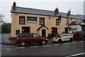
7
South side of the Lower New Inn gastropub, Lower New Inn
The Lancaster Road side of the gastropub on the corner of Newport Road.
Image: © Jaggery
Taken: 12 Apr 2018
0.04 miles
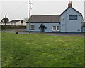
9
Newport Road houses, New Inn, Pontypool
The southern end of houses on this side of Newport Road.
Image: © Jaggery
Taken: 30 Apr 2023
0.04 miles
10
Houses at the southern edge of Lower New Inn
Viewed across Newport Road. The grey back of the Welcome to New Inn sign https://www.geograph.org.uk/photo/5735966 is on the right.
Image: © Jaggery
Taken: 12 Apr 2018
0.05 miles