IMAGES TAKEN NEAR TO
Walnut Grove, CALDICOT, NP26 5UX
Introduction
This page details the photographs taken nearby to Walnut Grove, NP26 5UX by members of the Geograph project.
The Geograph project started in 2005 with the aim of publishing, organising and preserving representative images for every square kilometre of Great Britain, Ireland and the Isle of Man.

There are currently over 7.5m images from over14,400 individuals and you can help contribute to the project by visiting https://www.geograph.org.uk
Image Map
Images are licensed for reuse under creativecommons.org/licenses/by-sa/2.0
Notes
- Clicking on the map will re-center to the selected point.
- The higher the marker number, the further away the image location is from the centre of the postcode.
Image Listing (24 Images Found)
Images are licensed for reuse under creativecommons.org/licenses/by-sa/2.0
Image
Details
Distance
1
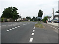
Crick - Start of Dual Carriageway
To the left is the road junction to Portskewett, just after which the dual carriageway starts, continuing to the outskirts of Caerwent.
Image: © Roy Parkhouse
Taken: 20 Jul 2006
0.02 miles
3

Rooftops of new housing estate, Crick, Monmouthshire
This estate is on the south side of Crick. Behind me as I took the picture is an area of woodland, mostly of birch trees.
Image: © Ruth Sharville
Taken: 25 Feb 2007
0.02 miles
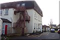
4
Bilingual lane name sign in rural Monmouthshire
English / Welsh name sign facing Crick Road.
Image: © Jaggery
Taken: 20 Aug 2023
0.06 miles
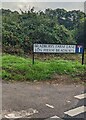
5

Lane to Bradbury's Farm, Crick, Monmouthshire
From Crick Road.
Image: © Jaggery
Taken: 20 Aug 2023
0.06 miles
6
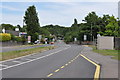
A48 looking towards Chepstow
Image: © Nick Mutton 01329 000000
Taken: 19 Jul 2010
0.07 miles
7

A48 and railway bridge carrying disused line to derelict Propellant factory
Image: © Nick Mutton 01329 000000
Taken: 19 Jul 2010
0.08 miles
8
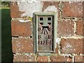
Ordnance Survey Flush Bracket S1354
This can be found on the wall of a house, Bradbury's - a private dwelling - in Crick.
For more detail see : http://www.bench-marks.org.uk/bm15775
Image: © Peter Wood
Taken: 21 Oct 2016
0.09 miles
9
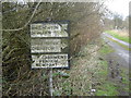
Old road sign, Crick
This road sign is evidence that the lane it is to be found in (photo http://www.geograph.org.uk/photo/347198 ), which is now a dead end thanks to the M48, used to be the main route through from Portskewett to Crick. They don't make them like this any more...
Image: © Ruth Sharville
Taken: 25 Feb 2007
0.10 miles
10
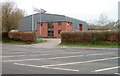
Sir Robert McAlpine premises, Crick
Located on the north side of the A48 immediately east of this http://www.geograph.org.uk/photo/2805549 bridge.
The company's business is engineering and construction work.
Image: © Jaggery
Taken: 31 Mar 2011
0.10 miles