IMAGES TAKEN NEAR TO
Caerwent, CALDICOT, NP26 5NN
Introduction
This page details the photographs taken nearby to NP26 5NN by members of the Geograph project.
The Geograph project started in 2005 with the aim of publishing, organising and preserving representative images for every square kilometre of Great Britain, Ireland and the Isle of Man.

There are currently over 7.5m images from over14,400 individuals and you can help contribute to the project by visiting https://www.geograph.org.uk
Image Map
Images are licensed for reuse under creativecommons.org/licenses/by-sa/2.0
Notes
- Clicking on the map will re-center to the selected point.
- The higher the marker number, the further away the image location is from the centre of the postcode.
Image Listing (35 Images Found)
Images are licensed for reuse under creativecommons.org/licenses/by-sa/2.0
Image
Details
Distance
1
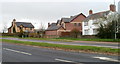
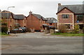
Houses at the eastern edge of Caerwent
Viewed across the A48. The house on the left is on the corner of Cwrt Morgan.http://www.geograph.org.uk/photo/2805355
Image: © Jaggery
Taken: 31 Mar 2011
0.09 miles
2
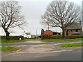
Entrance to Slough Farm near Caerwent
Viewed across the A48. A board on the left side of the farm entrance shows that potatoes, eggs, swedes and cabbages are on sale at the farmhouse.
Image: © Jaggery
Taken: 31 Mar 2011
0.09 miles
3
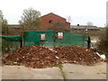
Mounds of earth and locked gates at the edge of a military training range near Caerwent
Viewed from the A48. The tops of the gates are lined with razor wire.
The notices on the gates, in Welsh and English, state
Military Training Range
Keep Out.
Image: © Jaggery
Taken: 31 Mar 2011
0.11 miles
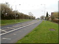
4
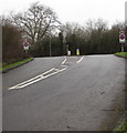
Eastern end of Roman Road, Caerwent
The 30mph speed limit on Roman Road increases to 50mph at the A48 junction.
Image: © Jaggery
Taken: 24 Jan 2016
0.12 miles
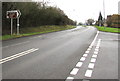
5
Junction of Roman Road and the A48, Caerwent
The bilingual name sign shows that ROMAN ROAD is HEOL RUFEINIG in Welsh.
Image: © Jaggery
Taken: 24 Jan 2016
0.12 miles
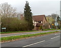
6
Caerwent boundary sign
Facing the A48 at the eastern end of Roman Road. Caerwent (Caer-went in Welsh) was founded by the Romans in 75 AD as Venta Silurum, a market town for the defeated Silures tribe.
Image: © Jaggery
Taken: 24 Jan 2016
0.12 miles
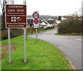
7
Direction sign alongside the A48, Caerwent
Turn right into Roman Road for Caerwent East (¼ mile), golf course (at Dewstow) and gardens (1¼ miles) and Caldicot Castle (2 miles).
Image: © Jaggery
Taken: 24 Jan 2016
0.12 miles
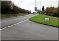
8
A48 heads east towards Crick
Viewed from the edge of the junction http://www.geograph.org.uk/photo/2805304 for Caerwent and Caldicot.
Image: © Jaggery
Taken: 31 Mar 2011
0.13 miles
9
Cwrt Morgan, Caerwent
Viewed across the A48. Cwrt Morgan is a residential cul-de-sac adjoining Slough Farm. http://www.geograph.org.uk/photo/2805379
Image: © Jaggery
Taken: 31 Mar 2011
0.13 miles
10
Eastern boundary of Caerwent
The A48 from Crick reaches Caerwent.
Image: © Jaggery
Taken: 31 Mar 2011
0.13 miles