IMAGES TAKEN NEAR TO
Hunters Ridge, CALDICOT, NP26 3PW
Introduction
This page details the photographs taken nearby to Hunters Ridge, NP26 3PW by members of the Geograph project.
The Geograph project started in 2005 with the aim of publishing, organising and preserving representative images for every square kilometre of Great Britain, Ireland and the Isle of Man.

There are currently over 7.5m images from over14,400 individuals and you can help contribute to the project by visiting https://www.geograph.org.uk
Image Map
Images are licensed for reuse under creativecommons.org/licenses/by-sa/2.0
Notes
- Clicking on the map will re-center to the selected point.
- The higher the marker number, the further away the image location is from the centre of the postcode.
Image Listing (36 Images Found)
Images are licensed for reuse under creativecommons.org/licenses/by-sa/2.0
Image
Details
Distance
1
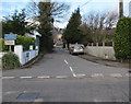
Vinegar Hill, Undy
The southern end of Vinegar Hill viewed across the B4245 here named Main Road.
The blue sign shows that Vinegar Hill is unsuitable for heavy goods vehicles.
The white sign below it shows No access to residential developments.
Image: © Jaggery
Taken: 11 Feb 2018
0.15 miles
2
Direction signs alongside the B4245 in Undy, Monmouthshire
Ahead along the B4245 for Cwrt Yr Eglwys or turn right into the Causeway https://www.geograph.org.uk/photo/5957362 for Undy AFC (Association Football Club).
Image: © Jaggery
Taken: 11 Feb 2018
0.15 miles
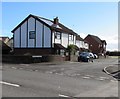
3
Corner of Vinegar Hill and Main Road, Undy
Vinegar Hill heads away from Main Road, the local name for the B4245. A blue sign at the start of Vinegar Hill states that the route is not suitable for heavy goods vehicles. The white sign below it states 'No access to residential developments'. The small white shop beside a tree is Nails by Design.
Image: © Jaggery
Taken: 14 Aug 2010
0.16 miles
4
Pelican crossing in Undy, Monmouthshire
Across the B4245 near the Causeway and Vinegar Hill junctions.
Chambers Dictionary states that pelican in this context is adapted from "pedestrian light controlled crossing".
Image: © Jaggery
Taken: 11 Feb 2018
0.16 miles
5
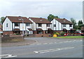
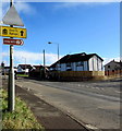
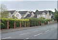
Tudor Court, Undy
Modern housing on the south side of the B4245.
Image: © Jaggery
Taken: 14 Aug 2010
0.17 miles
6
Tudor Court, Undy, Monmouthshire
Cul-de-sac on the south side of the B4245.
Image: © Jaggery
Taken: 11 Feb 2018
0.18 miles
7
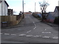
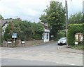
The Causeway, Undy, Monmouthshire
From the B4245, The Causeway leads to Undy AFC (Association Football Club)
and Undy Common via the railway bridge in the background.
Image: © Jaggery
Taken: 11 Feb 2018
0.20 miles
8
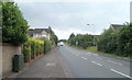
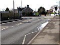
Elms Hill, Undy
The main road through the village of Undy, the B4245, is here named Elms Hill.
Image: © Jaggery
Taken: 14 Aug 2010
0.20 miles
9
St Stephens Court, Undy
Houses on St Stephens Court viewed from Elms Hill, the local name for this part of the B4245.
Image: © Jaggery
Taken: 14 Aug 2010
0.20 miles
10
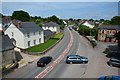
Magor : Main Road B4245
From the footbridge looking down into Magor.
Image: © Lewis Clarke
Taken: 1 Jun 2017
0.20 miles