IMAGES TAKEN NEAR TO
St. Brides Netherwent, CALDICOT, NP26 3AT
Introduction
This page details the photographs taken nearby to NP26 3AT by members of the Geograph project.
The Geograph project started in 2005 with the aim of publishing, organising and preserving representative images for every square kilometre of Great Britain, Ireland and the Isle of Man.

There are currently over 7.5m images from over14,400 individuals and you can help contribute to the project by visiting https://www.geograph.org.uk
Image Map
Images are licensed for reuse under creativecommons.org/licenses/by-sa/2.0
Notes
- Clicking on the map will re-center to the selected point.
- The higher the marker number, the further away the image location is from the centre of the postcode.
Image Listing (17 Images Found)
Images are licensed for reuse under creativecommons.org/licenses/by-sa/2.0
Image
Details
Distance
1
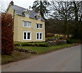
Homestead, St Brides Netherwent
House on the east side of St Brides Road.
Image: © Jaggery
Taken: 16 Feb 2012
0.01 miles
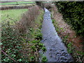
2
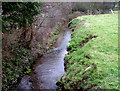
St Bride's Brook flows south through St Brides Netherwent
Viewed from the bridge connecting St Bridget's church http://www.geograph.org.uk/photo/3722456 with St Brides Road.
Image: © Jaggery
Taken: 16 Feb 2012
0.03 miles
3
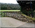
Start of a footpath from St Brides Netherwent to Magor via Salisbury Farm
Heading for Magor along St Brides Road, I considered using this path, but didn't do so, feeling uneasy about a route through a farm even though the sign on the right shows public footpath.
Image: © Jaggery
Taken: 16 Feb 2012
0.03 miles
4
St Bride's Brook from bridge, near St Brigid's Church
This bridge carries the footpath from Carrow Hill to and beyond Salisbury Farm. It also gives access to the church.
Image: © Ruth Sharville
Taken: 19 Apr 2007
0.04 miles
5
St Bride's Brook, St Brides Netherwent
The brook flow towards the bridge connecting St Bridget's church http://www.geograph.org.uk/photo/3722456 with St Brides Road.
Image: © Jaggery
Taken: 16 Feb 2012
0.04 miles
6
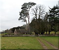
Trees at the northern edge of the churchyard, St Brides Netherwent
The trees are much taller than the church buildings. The church tower is unusually small. http://www.geograph.org.uk/photo/3722448
Image: © Jaggery
Taken: 16 Feb 2012
0.06 miles
7
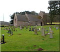
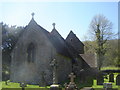
Church of St Bridget (or Brigid), St Brides Netherwent
St Bridget's church is built in the Early English style. The small tower, possibly 13th century, remains from the early church. The remainder of the church is an 1848 rebuild.
Image: © Jaggery
Taken: 16 Feb 2012
0.07 miles
8
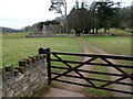
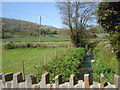
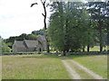
Track to the church, St Brides Netherwent
The track leads from St Brides Road to the Church of St Bridget (or Brigid). http://www.geograph.org.uk/photo/3722448
The stonework in the foreground is part of a small bridge over St Bride's Brook.
Image: © Jaggery
Taken: 16 Feb 2012
0.07 miles
9
Church of St Brigid, Netherwent
The church of St. Bridget or Brigid is set in quiet countryside, adjoining the site of a deserted medieval village. It was traditionally founded by Brochwael, the son of Meurig of Gwent, in the 10th century.
Image: © Eirian Evans
Taken: 25 Jun 2015
0.08 miles
10
St Brigid's Church, St Bride's Netherwent
The remains of a Mediaeval settlement are behind this little church.
Image: © Ruth Sharville
Taken: 19 Apr 2007
0.09 miles