IMAGES TAKEN NEAR TO
Llangattock, MONMOUTH, NP25 5NJ
Introduction
This page details the photographs taken nearby to NP25 5NJ by members of the Geograph project.
The Geograph project started in 2005 with the aim of publishing, organising and preserving representative images for every square kilometre of Great Britain, Ireland and the Isle of Man.

There are currently over 7.5m images from over14,400 individuals and you can help contribute to the project by visiting https://www.geograph.org.uk
Image Map
Images are licensed for reuse under creativecommons.org/licenses/by-sa/2.0
Notes
- Clicking on the map will re-center to the selected point.
- The higher the marker number, the further away the image location is from the centre of the postcode.
Image Listing (59 Images Found)
Images are licensed for reuse under creativecommons.org/licenses/by-sa/2.0
Image
Details
Distance
1
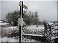
Footpath finger post near Llangattock-Vibon-Avel in March
The laminated A4 poster advises of Palm Sunday services at St. Cadoc's church.
Image: © Jeremy Bolwell
Taken: 23 Mar 2013
0.02 miles
2
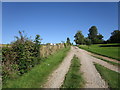
Tracks at Llangattock-Vibon-Avel
Looking towards The White House.
Image: © Jonathan Thacker
Taken: 18 Sep 2019
0.03 miles
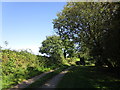
3
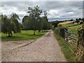
Track at Llangattock-Vibon-Avel
We followed this track to find the parish church of St. Cadoc, now managed by the Friends of Friendless Churches.
Image: © Fabian Musto
Taken: 2 Aug 2024
0.06 miles
4
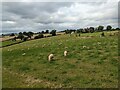
Sheep at Llangattock-Vibon-Avel
Sheep grazing in a field south of Llangattock School, which can be seen in the background to the right. The hill in the background to the left is the Skirrid (Ysgyryd Fawr).
Image: © Fabian Musto
Taken: 2 Aug 2024
0.07 miles
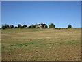
5
Farmland to the north of Llangattock Manor
Skirrid is just visible on the horizon on the left.
Image: © Philip Halling
Taken: 23 Sep 2006
0.07 miles
6
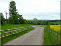
Tracks diverge
The public path to the St. Cadoc's church, Image, is to the right.
Left is the private road to llangattock Farm.
Image: © Jonathan Billinger
Taken: 22 May 2009
0.07 miles
7

Puddles on the road, Llangattock-Vibon-Avel
Viewed on January 16th 2022. Ahead for Rockfield and Monmouth.
Image: © Jaggery
Taken: 16 Jan 2022
0.09 miles
8
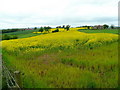
Arable Monmouthshire
For all its hills, this corner of the county is quite arable - here is a rape crop near Llangattock-Vibon-Avel.
Image: © Jonathan Billinger
Taken: 22 May 2009
0.09 miles
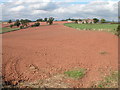
10
Stubble field and school, Llangattock-Vibon-Avel
Image: © Jonathan Thacker
Taken: 18 Sep 2019
0.12 miles