IMAGES TAKEN NEAR TO
Jordan Close, MONMOUTH, NP25 5EB
Introduction
This page details the photographs taken nearby to Jordan Close, NP25 5EB by members of the Geograph project.
The Geograph project started in 2005 with the aim of publishing, organising and preserving representative images for every square kilometre of Great Britain, Ireland and the Isle of Man.

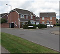
There are currently over 7.5m images from over14,400 individuals and you can help contribute to the project by visiting https://www.geograph.org.uk
Image Map
Images are licensed for reuse under creativecommons.org/licenses/by-sa/2.0
Notes
- Clicking on the map will re-center to the selected point.
- The higher the marker number, the further away the image location is from the centre of the postcode.
Image Listing (24 Images Found)
Images are licensed for reuse under creativecommons.org/licenses/by-sa/2.0
Image
Details
Distance
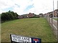
1
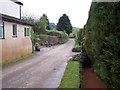
Watery Lane
Well named lane west of Monmouth, with water channel acting as drainage system
Image: © Chris Heaton
Taken: 8 May 2006
0.08 miles
2
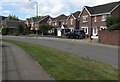
Chartist Rise, Monmouth
This part of Chartist Rise is between the Cornpoppy Avenue junction
near the camera and the Cornwallis Way junction out of shot ahead.
Image: © Jaggery
Taken: 18 Aug 2020
0.09 miles
3
Watery Lane, Monmouth
Looking to the WSW along Watery Lane from near the Chartist Rise junction.
Image: © Jaggery
Taken: 18 Aug 2020
0.13 miles
4
Field on a Monmouth corner
On the corner of Chartist Rise and Watery Lane (Lôn Dyfriog in Welsh).
Image: © Jaggery
Taken: 18 Aug 2020
0.13 miles
5
Corner of Chartist Rise and Cornpoppy Avenue, Monmouth
Houses at the southern end of Cornpoppy Avenue viewed across Chartist Rise.
Image: © Jaggery
Taken: 18 Aug 2020
0.14 miles
6
North along Cornpoppy Avenue, Monmouth
Viewed across Chartist Rise. The bilingual name sign on the left
shows that Cornpoppy Avenue is Rhodfa Blodau'r Wig in Welsh.
Image: © Jaggery
Taken: 18 Aug 2020
0.14 miles
7
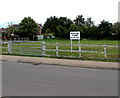
Private Land - Keep Out, Chartist Rise, Monmouth
Viewed in August 2020. Neither the sign nor fences were here in a June 2011 Google Street View.
Image: © Jaggery
Taken: 18 Aug 2020
0.16 miles
8
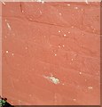
Ordnance Survey Cut Mark
This OS cut mark can be found on No1 Brook Crescent. It marks a point 21.652m above mean sea level.
Image: © Adrian Dust
Taken: 30 Jan 2019
0.16 miles
9
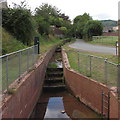
Stepped water channel in Monmouth
Below Watery Lane on the right.
Image: © Jaggery
Taken: 18 Aug 2020
0.16 miles
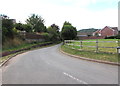
10
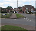
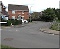
Junction of Watery Lane and Chartist Rise, Monmouth
Watery Lane behind the camera continues beyond the left edge of the photo. The bilingual name sign shows that Watery Lane is Lôn Dyfriog in Welsh. The road ahead is Chartist Rise.
Image: © Jaggery
Taken: 18 Aug 2020
0.17 miles