IMAGES TAKEN NEAR TO
Drybridge Park, MONMOUTH, NP25 5BL
Introduction
This page details the photographs taken nearby to Drybridge Park, NP25 5BL by members of the Geograph project.
The Geograph project started in 2005 with the aim of publishing, organising and preserving representative images for every square kilometre of Great Britain, Ireland and the Isle of Man.

There are currently over 7.5m images from over14,400 individuals and you can help contribute to the project by visiting https://www.geograph.org.uk
Image Map
Images are licensed for reuse under creativecommons.org/licenses/by-sa/2.0
Notes
- Clicking on the map will re-center to the selected point.
- The higher the marker number, the further away the image location is from the centre of the postcode.
Image Listing (399 Images Found)
Images are licensed for reuse under creativecommons.org/licenses/by-sa/2.0
Image
Details
Distance
1
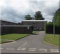
Road to Care Facilities
This is the access road to the Monnow Vale Health and Social Care Facility, with associated sheltered housing.
Image: © Jonathan Billinger
Taken: 11 Sep 2018
0.03 miles
2
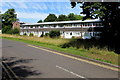
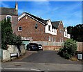
Row of houses west of Rockfield Road, Monmouth
Located between the B4233 Rockfield Road and Monnow Vale Hospital out of shot ahead.
Image: © Jaggery
Taken: 12 Jul 2020
0.06 miles
3
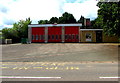
Fire station and tower
Rockfield Road, Monmouth.
Image: © Pauline E
Taken: 7 Apr 2009
0.07 miles
4
Ambulance Station, Rockfield Road
Next to the fire station.
Image: © Pauline E
Taken: 7 Apr 2009
0.07 miles
5
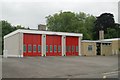
Monmouth Fire Station
Part of the South Wales Fire and Rescue Service, the fire station is set back from the B4233 Rockfield Road near Monmouth Ambulance Station. https://www.geograph.org.uk/photo/6573851
Image: © Jaggery
Taken: 18 Aug 2020
0.07 miles
6
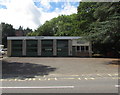
Monmouth Fire Station
Monmouth Fire Station, Rockfield Road, Monmouth is one of the 50 fire stations making up South Wales Fire & Rescue Service
Image: © Kevin Hale
Taken: 3 Jun 2007
0.08 miles
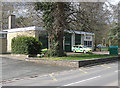
7
Yellow donations bin, Rockfield Road, Monmouth
Located near Monmouth Fire Station https://www.geograph.org.uk/photo/6573857 the yellow bin is for donations of shoes and clothing to the Firefighters Charity. Proceeds from the sale of these items help injured firefighters.
Image: © Jaggery
Taken: 18 Aug 2020
0.08 miles
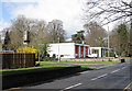
8
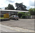
Monmouth Ambulance Station
Set back from the B4233 Rockfield Road near Monmouth Fire Station. https://www.geograph.org.uk/photo/6573857
Image: © Jaggery
Taken: 18 Aug 2020
0.08 miles
9
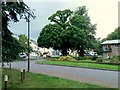
Entrance to Drybridge Park, Monmouth
Road from the B4233 Rockfield Road to flats in Drybridge Park.
Image: © Jaggery
Taken: 18 Aug 2020
0.08 miles
10
Williams Field Lane, Monmouth
Cul-de-sac viewed across Wonastow Road in July 2020.
The bilingual sign on the left shows that Williams Field Lane is Lôn Maes William in Welsh.
The arrow on the sign on the right points towards Drybridge Veterinary Clinic.
Image: © Jaggery
Taken: 12 Jul 2020
0.09 miles