IMAGES TAKEN NEAR TO
Brook Estate, MONMOUTH, NP25 5AN
Introduction
This page details the photographs taken nearby to Brook Estate, NP25 5AN by members of the Geograph project.
The Geograph project started in 2005 with the aim of publishing, organising and preserving representative images for every square kilometre of Great Britain, Ireland and the Isle of Man.

There are currently over 7.5m images from over14,400 individuals and you can help contribute to the project by visiting https://www.geograph.org.uk
Image Map
Images are licensed for reuse under creativecommons.org/licenses/by-sa/2.0
Notes
- Clicking on the map will re-center to the selected point.
- The higher the marker number, the further away the image location is from the centre of the postcode.
Image Listing (50 Images Found)
Images are licensed for reuse under creativecommons.org/licenses/by-sa/2.0
Image
Details
Distance
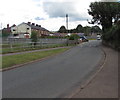
1
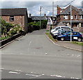
Into Brook Estate, Monmouth
From the north side of Watery Lane.
Image: © Jaggery
Taken: 18 Aug 2020
0.03 miles
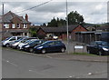
2
Row of houses set back from Watery Lane, Monmouth
On the corner of Watery Lane and Brook Estate.
Image: © Jaggery
Taken: 18 Aug 2020
0.04 miles
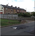
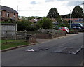
3
Fenced-off lockup garages, Brook Estate, Monmouth
Cars are parked near the out-of-use garages in August 2020.
Image: © Jaggery
Taken: 18 Aug 2020
0.05 miles
4
North along Cornpoppy Avenue, Monmouth
Viewed across Chartist Rise. The bilingual name sign on the left
shows that Cornpoppy Avenue is Rhodfa Blodau'r Wig in Welsh.
Image: © Jaggery
Taken: 18 Aug 2020
0.06 miles
5
East along Watery Lane, Monmouth
Ahead for Rockfield Road.
Image: © Jaggery
Taken: 18 Aug 2020
0.06 miles
7
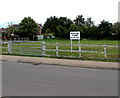
Private Land - Keep Out, Chartist Rise, Monmouth
Viewed in August 2020. Neither the sign nor fences were here in a June 2011 Google Street View.
Image: © Jaggery
Taken: 18 Aug 2020
0.06 miles
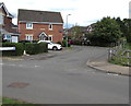
8
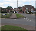
Junction of Watery Lane and Chartist Rise, Monmouth
Watery Lane behind the camera continues beyond the left edge of the photo. The bilingual name sign shows that Watery Lane is Lôn Dyfriog in Welsh. The road ahead is Chartist Rise.
Image: © Jaggery
Taken: 18 Aug 2020
0.06 miles
9
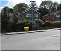
Yellow amid green, St Thomas Road, Monmouth
The yellow salt/grit box is at the northern end of St Thomas Road, near the Watery Lane junction.
Image: © Jaggery
Taken: 18 Aug 2020
0.07 miles
10
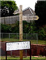
Offa's Dyke Path signpost detail, Watery Lane, Monmouth
Located here. https://www.geograph.org.uk/photo/6573071 Left for Monmouth town centre. Right for Pandy. 16 milltir is Welsh for 16 miles. Offa's Dyke Path is a long-distance footpath broadly following the Wales/England border. It extends from Chepstow in the south of South Wales to Prestatyn in the north of North Wales.
Image: © Jaggery
Taken: 18 Aug 2020
0.07 miles