IMAGES TAKEN NEAR TO
Llandogo, MONMOUTH, NP25 4TW
Introduction
This page details the photographs taken nearby to NP25 4TW by members of the Geograph project.
The Geograph project started in 2005 with the aim of publishing, organising and preserving representative images for every square kilometre of Great Britain, Ireland and the Isle of Man.

There are currently over 7.5m images from over14,400 individuals and you can help contribute to the project by visiting https://www.geograph.org.uk
Image Map
Images are licensed for reuse under creativecommons.org/licenses/by-sa/2.0
Notes
- Clicking on the map will re-center to the selected point.
- The higher the marker number, the further away the image location is from the centre of the postcode.
Image Listing (38 Images Found)
Images are licensed for reuse under creativecommons.org/licenses/by-sa/2.0
Image
Details
Distance
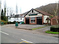
1
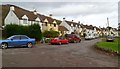
Hudnalls View, Llandogo
Hudnalls View is a residential street of 12 houses set back from the north side of the A466.
Image: © Jaggery
Taken: 4 Dec 2011
0.05 miles
3
Holmfield Drive Llandogo
Houses at the corner of Holmfield Drive and The Woodlands, on the north side of the A466.
Image: © Jaggery
Taken: 4 Dec 2011
0.11 miles
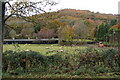
4
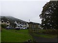
Looking down on Llandogo
Playground in midground
Image: © Clive Perrin
Taken: 20 May 2012
0.13 miles
5
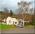
Abbie Carpets and Flooring, Llandogo
Located in The Old Garage, alongside the A466 just beyond the eastern boundary of Llandogo.
Lettering on the windows shows CARPETS REMNANTS VINYLS.
Image: © Jaggery
Taken: 4 Dec 2011
0.14 miles
6
Eastern boundary of Llandogo
The A466, from Monmouth, reaches the edge of the small village of Llandogo, located in the Wye Valley about 2 miles north of Tintern.
Image: © Jaggery
Taken: 4 Dec 2011
0.14 miles
7
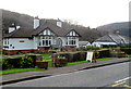
B&B, Rosehurst, Llandogo
Bungalow located alongside the A466 near the eastern edge of Llandogo. A board on the pavement shows BED & BREAKFAST WELCOME.
Image: © Jaggery
Taken: 4 Dec 2011
0.14 miles
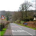
9
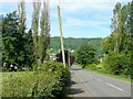
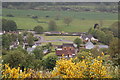
A466 Wye Valley Road
Looking south-west towards Llandogo set on the steep valley side.
Image: © Jonathan Billinger
Taken: 21 Jun 2010
0.16 miles
10
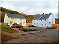
Tulip Gardens, Llandogo
These 4 Monmouthshire Housing Association houses were officially opened on March 2nd 2011.
Tulip Gardens was the winning entry from a pupil at the nearby primary school http://www.geograph.org.uk/photo/2720004 in a competition to name the new street. Two local councillors stated that they were very pleased that affordable family housing had been built in this rural area.
Image: © Jaggery
Taken: 4 Dec 2011
0.17 miles