IMAGES TAKEN NEAR TO
Cleddon, MONMOUTH, NP25 4PW
Introduction
This page details the photographs taken nearby to Cleddon, NP25 4PW by members of the Geograph project.
The Geograph project started in 2005 with the aim of publishing, organising and preserving representative images for every square kilometre of Great Britain, Ireland and the Isle of Man.

There are currently over 7.5m images from over14,400 individuals and you can help contribute to the project by visiting https://www.geograph.org.uk
Image Map
Images are licensed for reuse under creativecommons.org/licenses/by-sa/2.0
Notes
- Clicking on the map will re-center to the selected point.
- The higher the marker number, the further away the image location is from the centre of the postcode.
Image Listing (9 Images Found)
Images are licensed for reuse under creativecommons.org/licenses/by-sa/2.0
Image
Details
Distance
1
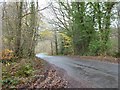
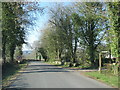
Road passing through Ninewells Wood
Country road to Trellech passing through Ninewells Wood.
Image: © Philip Halling
Taken: 23 Nov 2017
0.04 miles
2
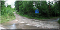
Cleddon road junction
The road from Trellech to Cleddon and Cleddon Falls runs left to right in this photograph and is, as the sign states, unsuitable for heavy goods vehicles. The track in the middle leads to Beacon Hill.
Image: © Roy Parkhouse
Taken: 29 Jun 2007
0.05 miles
3
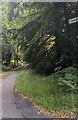
Narrow road towards Cleddon, Monmouthshire
Looking east from Llandogo Road
Image: © Jaggery
Taken: 18 Aug 2024
0.08 miles
4
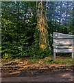
Ninewells Wood nameboard, Monmouthshire
Natural Resources Wales board alongside the road
to Trellech on the approach to the Ninewells Wood car park.
Image: © Jaggery
Taken: 18 Aug 2024
0.09 miles
5
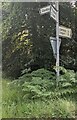
Direction and distances signs near Cleddon, Monmouthshire
Left on this https://www.geograph.org.uk/photo/7854078 narrow road for Cleddon.
Ahead for Llandogo (2¼ miles) and Tintern (2½).
Behind the camera for Trelleck and Monmouth.
Image: © Jaggery
Taken: 18 Aug 2024
0.09 miles
6
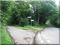
Cleddon road junction
The road to the left leads to Cleddon and Cleddon Falls; that to the right to Llandogo and Tintern.
Image: © Roy Parkhouse
Taken: 29 Jun 2007
0.12 miles
7
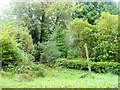
An overgrown green lane
Heading east towards Cleddon and Llandogo.
Image: © Jonathan Billinger
Taken: 23 Sep 2011
0.20 miles
8
Road passes the start of the footpath to Cleddon
Image: © Sarah Charlesworth
Taken: 7 Mar 2011
0.23 miles
9
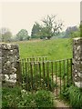
Kissing Gate leading to Cleddon Hall Footpath
Image: © Claire Seyler
Taken: 29 Apr 2011
0.24 miles