IMAGES TAKEN NEAR TO
Almshouse Street, MONMOUTH, NP25 3XP
Introduction
This page details the photographs taken nearby to Almshouse Street, NP25 3XP by members of the Geograph project.
The Geograph project started in 2005 with the aim of publishing, organising and preserving representative images for every square kilometre of Great Britain, Ireland and the Isle of Man.

There are currently over 7.5m images from over14,400 individuals and you can help contribute to the project by visiting https://www.geograph.org.uk
Image Map
Images are licensed for reuse under creativecommons.org/licenses/by-sa/2.0
Notes
- Clicking on the map will re-center to the selected point.
- The higher the marker number, the further away the image location is from the centre of the postcode.
Image Listing (988 Images Found)
Images are licensed for reuse under creativecommons.org/licenses/by-sa/2.0
Image
Details
Distance
1
Recently erected building in Monmouth School
Viewed in late October 2014. The 3-storey building near Glendower Street, Monmouth,
has replaced the 2-storey building seen here http://www.geograph.org.uk/photo/2098657 on the right in 2010
Image: © Jaggery
Taken: 26 Oct 2014
0.01 miles
2
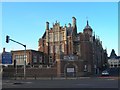
Monmouth School
Monmouth School at the junction on the A40 opposite the Wye Bridge. http://www.monmouthschool.org/
Image: © David P Howard
Taken: 28 Nov 2010
0.01 miles
3
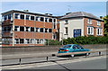
Part of the east side of Monmouth School
Viewed across the A40. These are some of the newer buildings in Monmouth School, a boarding and day school for boys aged 7-18. Monmouth School was established in 1614 but nothing remains of the original buildings. Many of the school buildings date from 1865, when the school was substantially rebuilt on the same site. Here http://www.geograph.org.uk/photo/2098646 is a more typical part of the school.
Image: © Jaggery
Taken: 2 May 2011
0.03 miles
4
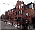
![Monmouth buildings [38]](https://s2.geograph.org.uk/geophotos/06/93/50/6935018_d9d27b7a_120x120.jpg)
Monmouth buildings [38]
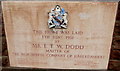
A niche in the gable end of the almshouses seen at Image which reads 'These alms-houses were founded A.D.1616 by Mr. William Jones Citizen and Haberdasher of London. Rebuilt by the Governors the Worshipful Company of Haberdashers London 1842 Thomas Howell Esq. Master J B Bunning Archt.'
Now used as offices, the almshouses were incorporated into Monmouth Boys School in 1961 when they were replaced by the almshouses in Whitecross Street. Constructed of red sandstone with Bath stone dressings and a Welsh slate roof.
Listed, grade II, with details at: https://cadwpublic-api.azurewebsites.net/reports/listedbuilding/FullReport?lang=&id=2245
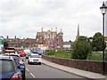
Monmouth is a market town at the confluence of the Rivers Monnow and Wye some 30 miles northeast of Cardiff. Although there is evidence of settlement in the Neolithic period, the town was established around the Norman castle which was the birthplace of King Henry V. The historic county town of Monmouthshire, the town is now a centre for Wye Valley tourism.
Image: © Michael Dibb
Taken: 4 Jun 2021
0.04 miles
5
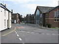
Entrance to Monmouth Boys School, Almshouse Street
Image: © Nick Smith
Taken: 21 Apr 2011
0.04 miles
6
Blake Theatre foundation stone, Monmouth
Located on the left side of this http://www.geograph.org.uk/photo/2098651 building which was originally part of Monmouth School.
Image: © Jaggery
Taken: 26 Apr 2015
0.04 miles
7
![Monmouth buildings [37]](https://s0.geograph.org.uk/geophotos/06/93/50/6935016_91b10294_120x120.jpg)
Monmouth buildings [37]
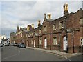
These delightful almshouses were built in 1843 to replace the almshouses of 1616 which were a part of the Haberdashers Company foundation together with Monmouth Boys School. Now used as offices, they were incorporated into the school in 1961 when they were replaced by the almshouses in Whitecross Street. Constructed of red sandstone with Bath stone dressings and a Welsh slate roof. See also Image Listed, grade II, with details at: https://cadwpublic-api.azurewebsites.net/reports/listedbuilding/FullReport?lang=&id=2245
Monmouth is a market town at the confluence of the Rivers Monnow and Wye some 30 miles northeast of Cardiff. Although there is evidence of settlement in the Neolithic period, the town was established around the Norman castle which was the birthplace of King Henry V. The historic county town of Monmouthshire, the town is now a centre for Wye Valley tourism.
Image: © Michael Dibb
Taken: 4 Jun 2021
0.04 miles
8
Monmouth Boys' School
Founded in 1614.
Image: © Eirian Evans
Taken: 30 Aug 2019
0.05 miles
9
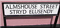
Almshouse Street/Stryd Elusendy name sign, Monmouth
The English/Welsh street name sign is located here. https://www.geograph.org.uk/photo/5804657
Image: © Jaggery
Taken: 10 Jun 2018
0.05 miles
10
Monmouth - Almshouse Street
Monmouth Alms Houses were founded in 1614 by William Jones, a wealthy merchant. They were rebuilt in 1842 and 1961.
https://en.wikipedia.org/wiki/Monmouth_Alms_Houses
Image: © Colin Smith
Taken: 4 Aug 2023
0.05 miles