Monmouth buildings [38]
Introduction
The photograph on this page of Monmouth buildings [38] by Michael Dibb as part of the Geograph project.
The Geograph project started in 2005 with the aim of publishing, organising and preserving representative images for every square kilometre of Great Britain, Ireland and the Isle of Man.

There are currently over 7.5m images from over 14,400 individuals and you can help contribute to the project by visiting https://www.geograph.org.uk
Monmouth buildings [38]
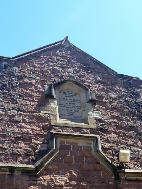
Image: © Michael Dibb Taken: 4 Jun 2021
A niche in the gable end of the almshouses seen at Image which reads 'These alms-houses were founded A.D.1616 by Mr. William Jones Citizen and Haberdasher of London. Rebuilt by the Governors the Worshipful Company of Haberdashers London 1842 Thomas Howell Esq. Master J B Bunning Archt.' Now used as offices, the almshouses were incorporated into Monmouth Boys School in 1961 when they were replaced by the almshouses in Whitecross Street. Constructed of red sandstone with Bath stone dressings and a Welsh slate roof. Listed, grade II, with details at: https://cadwpublic-api.azurewebsites.net/reports/listedbuilding/FullReport?lang=&id=2245 Monmouth is a market town at the confluence of the Rivers Monnow and Wye some 30 miles northeast of Cardiff. Although there is evidence of settlement in the Neolithic period, the town was established around the Norman castle which was the birthplace of King Henry V. The historic county town of Monmouthshire, the town is now a centre for Wye Valley tourism.
Images are licensed for reuse under creativecommons.org/licenses/by-sa/2.0
Image Location
Latitude
51.81131
Longitude
-2.712742